
Fișier:Vancouver1798map-SanJuan-Gulf.png
Mărimea acestei previzualizări: 521 × 599 pixeli. Alte rezoluții: 209 × 240 pixeli | 417 × 480 pixeli | 766 × 881 pixeli.
Mărește rezoluția imaginii (766 × 881 pixeli, mărime fișier: 1,39 MB, tip MIME: image/png)
| Acest fișier se află la Wikimedia Commons. Consultați pagina sa descriptivă acolo. |
Descriere fișier
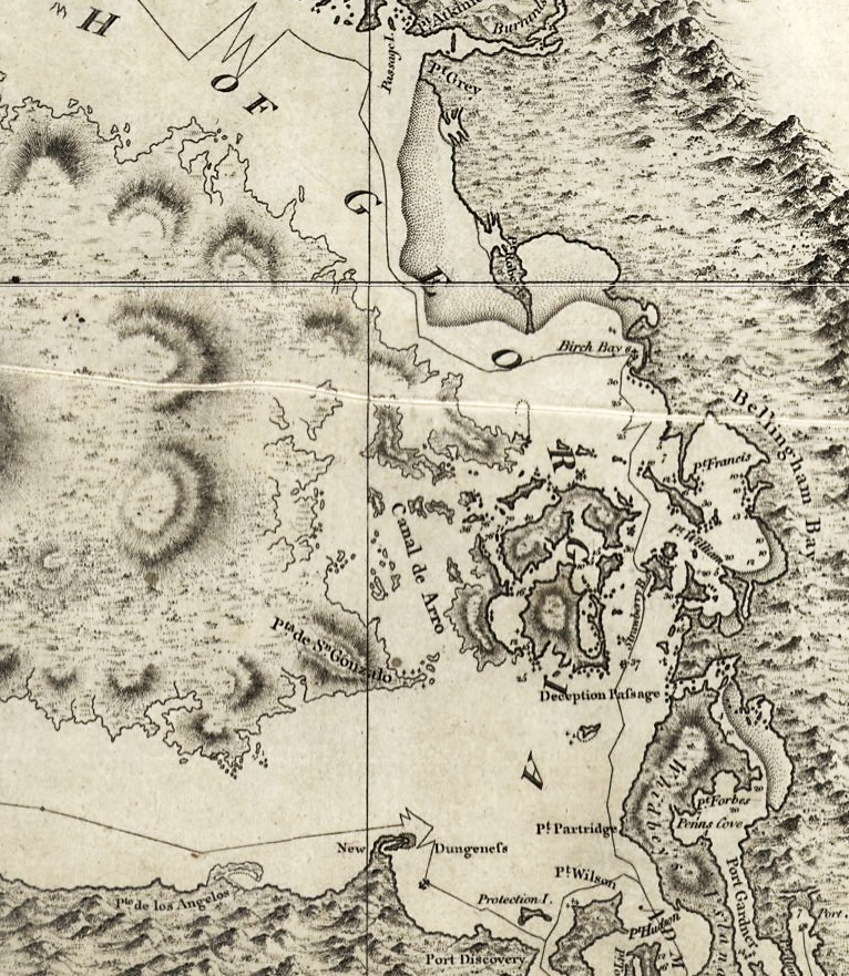
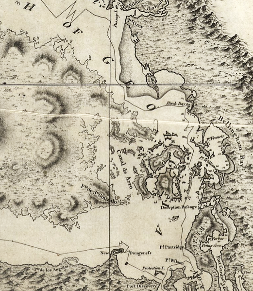
| Descriere | Excerpt of a map by George Vancouver, titled "A chart shewing part of the coast of N.W. America : with the tracks of His Majesty's sloop Discovery and armed tender Chatham / commanded by George Vancouver, Esqr. and prepared under his immediate inspection by Lieut. Joseph Baker..."; published 1798 |
| Dată | |
| Sursă | http://hdl.loc.gov/loc.gmd/g3512c.ct000914 |
| Autor | George Vancouver; digital version, Library of Congress, Geography and Map Division. |
| Permisiune (Reutilizarea acestui fișier) |
"The Library of Congress is providing access to these materials for educational and research purposes and is not aware of any U.S. copyright protection" (source: [1]) |
Licențiere
This work is in the public domain in the United States because it is a work prepared by an officer or employee of the United States Government as part of that person’s official duties under the terms of Title 17, Chapter 1, Section 105 of the US Code.
Note: This only applies to original works of the Federal Government and not to the work of any individual U.S. state, territory, commonwealth, county, municipality, or any other subdivision. This template also does not apply to postage stamp designs published by the United States Postal Service since 1978. (See § 313.6(C)(1) of Compendium of U.S. Copyright Office Practices). It also does not apply to certain US coins; see The US Mint Terms of Use.
|
 | |
| Acest fișier a fost identificat ca fiind liber de orice restricții cunoscute privind legea drepturilor de autor, inclusiv toate drepturile conexe sau înrudite. | ||

|
Această map este disponibilă pe pagina Geography & Map Division a Bibliotecii Congresului Statelor Unite ale Americii, sub numărul de identificare ct000914 g3512c ct000914.
Acest format nu indică statutul de drept de autor sau sursa lucrării atașate. Un format normal și o sursă sunt de asemenea necesare. Vezi Commons:Licenţiere pentru mai multe informații.
|
Istoricul fișierului
Apăsați pe Data și ora pentru a vedea versiunea trimisă atunci.
| Data și ora | Miniatură | Dimensiuni | Utilizator | Comentariu | |
|---|---|---|---|---|---|
| actuală | 16 mai 2008 09:42 | | 766x881 (1,39 MB) | Pfly | {{Information |Description=Excerpt of a map by George Vancouver, titled "A chart shewing part of the coast of N.W. America : with the tracks of His Majesty's sloop Discovery and armed tender Chatham / commanded by George Vancouver, Esqr. and prepared unde |
Utilizarea fișierului
Următoarele pagini conțin această imagine:
Utilizarea globală a fișierului
Următoarele alte proiecte wiki folosesc acest fișier:
- Utilizare la en.wikipedia.org
- Utilizare la he.wikipedia.org
- Utilizare la hy.wikipedia.org
- Utilizare la ja.wikipedia.org
- Utilizare la no.wikipedia.org
- Utilizare la ru.wikipedia.org
- Utilizare la th.wikipedia.org
- Utilizare la uk.wikipedia.org