
Fișier:Location Ryukyu Islands.PNG

Mărimea acestei previzualizări: 550 × 599 pixeli. Alte rezoluții: 220 × 240 pixeli | 441 × 480 pixeli | 906 × 987 pixeli.
Mărește rezoluția imaginii (906 × 987 pixeli, mărime fișier: 151 KB, tip MIME: image/png)
| Acest fișier se află la Wikimedia Commons. Consultați pagina sa descriptivă acolo. |
Descriere fișier
| Descriere |
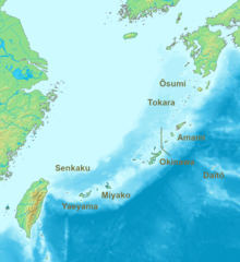
English: Location map of the Ryukyu islands (Nansei islands). According to the standardized geographical names of Japan, the Nansei Islands (南西諸島, Nansei Shotō, lit. "Southwest Islands") cover the entire island chain: the Ōsumi, Tokara, Amami, Okinawa, Sakishima Islands (further divided into the Miyako and Yaeyama Islands), the Senkaku Islands, and the Daitō Islands, with Yonaguni the westernmost. |
| Dată | 2006, 2022 |
| Sursă | Operă proprie |
| Autor | Nanshu, Michiel1972 |
| Alte versiuni | alternative version: File:Location of the Ryukyu Islands.JPG |
Licențiere
This image is in the public domain because it came from the site https://www.demis.nl/products/web-map-server/examples/ and was released by the copyright holder. Permission is granted to copy, distribute and/or modify this map since it is based on free of copyright images from: www.demis.nl. See also approval email on de.wp and its clarification.
|
| This work has been released into the public domain by its copyright holder, www.demis.nl. This applies worldwide. În anumite țări există posibilitatea ca acest lucru să nu fie legal posibil; în acest caz: www.demis.nl permite oricui să utilizeze această operă în orice scop, fără nicio condiție, atâta timp cât asemenea condiții nu sunt cerute de lege.
|
Istoricul fișierului
Apăsați pe Data și ora pentru a vedea versiunea trimisă atunci.
| Data și ora | Miniatură | Dimensiuni | Utilizator | Comentariu | |
|---|---|---|---|---|---|
| actuală | 21 mai 2022 10:53 | | 906x987 (151 KB) | A1Cafel | Reverted to version as of 08:43, 3 April 2022 (UTC) |
| 13 mai 2022 10:26 |  | 2.309x1.594 (527 KB) | Sturmgewehr88 | Higher resolution map | |
| 3 aprilie 2022 11:43 |  | 906x987 (151 KB) | Nanshu | Adjust locations. Larger labels. | |
| 20 ianuarie 2006 01:45 |  | 482x377 (85 KB) | Michiel1972 | *Location_Ryukyu_Islands {{demis}} |
Utilizarea fișierului
Următoarele pagini conțin această imagine:
Utilizarea globală a fișierului
Următoarele alte proiecte wiki folosesc acest fișier:
- Utilizare la ar.wikipedia.org
- Utilizare la en.wikipedia.org
- Utilizare la fr.wikipedia.org
- Utilizare la hak.wikipedia.org
- Utilizare la sn.wikipedia.org
- Utilizare la uk.wikipedia.org
- Utilizare la zh-min-nan.wikipedia.org
- Utilizare la zh-yue.wikipedia.org
- Utilizare la zh.wikipedia.org