
Fișier:Le Castellet circuit map Formula One 2018 without corner names English 29 06 2021.svg

Mărimea acestei previzualizări PNG a acestui fișier SVG: 673 × 599 pixeli. Alte rezoluții: 270 × 240 pixeli | 539 × 480 pixeli | 863 × 768 pixeli | 1.150 × 1.024 pixeli | 2.300 × 2.048 pixeli | 2.191 × 1.951 pixeli.
Mărește rezoluția imaginii (Fișier SVG, cu dimensiunea nominală de 2.191 × 1.951 pixeli, mărime fișier: 59 KB)
| Acest fișier se află la Wikimedia Commons. Consultați pagina sa descriptivă acolo. |
Descriere fișier
| Descriere |
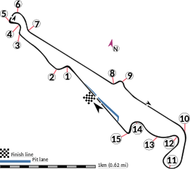
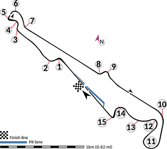
English: This is an altered version of File:Le Castellet circuit map Formula One 2018 without corner names June 2021.svg with the key solely in English and a few other alterations. This is a map of the Le Castellet motor circuit as it was used by w:en:Formula One for the w:en:2018 French Grand Prix, before the pit lane entrances and exits were reconfigured, and includes corner numbers and other information sourced from the FIA's map of the circuit. This map is valid for races which use this layout and corner numbering scheme, please upload a new file for races which use different layouts or corner numbering schemes rather than replacing this file. As this is a free-hand map drawn by an enthusiast rather than a professional cartographer's work it may contain some errors, although checking it against other maps it appears accurate enough for most purposes. The track is shown in black with a grey outline, while the pit lane is shown in blue. A scale showing the length of one kilometre (with increments of 100 metres) is given, to allow viewers to contextualise and understand what they are looking at. Corner numbers and other important text is given an off-white background to avoid transparency issues rendering it illegible on certain devices. A thick white line covering the track and the pit lane, marked with a chequered flag, shows the location of the start/finish line, also known as the control or timing line. A thinner white line, covering only the track, shows the location of pole position, and is marked with a large black arrow indicating the direction of travel. There are also thin white lines crossing the track which indicate the ends of the first and second timing sectors used by Formula One; these are marked with smaller black arrows, which also indicate the direction of travel. The mauve arrow marked "N" shows the direction of north.
Arrow pointing north Pit lane Links corner number to location of corner |
| Dată | |
| Sursă | Operă proprie |
| Autor | HumanBodyPiloter5 |
| Alte versiuni |
   |
Licențiere
Eu, deținătorul drepturilor de autor ale acestei opere, prin prezenta îmi public lucrarea sub următoarea licență:
| Acest fișier a fost eliberat sub licența Creative Commons CC0 1.0 Universal Public Domain Dedication. | |
| Persoana care a asociat o operă cu acest document o oferă domeniului public, renunțând la toate drepturile asupra operei, în toată lumea, atât în ce privește drepturile de autor cât și orice alte drepturi juridice conexe pe care le avea asupra operei, în măsura permisă de lege. Puteți copia, modifica sau distribui opera, inclusiv în scopuri comerciale, fără a fi necesară permisiunea autorului.
|
Istoricul fișierului
Apăsați pe Data și ora pentru a vedea versiunea trimisă atunci.
| Data și ora | Miniatură | Dimensiuni | Utilizator | Comentariu | |
|---|---|---|---|---|---|
| actuală | 29 iunie 2021 04:15 | | 2.191x1.951 (59 KB) | HumanBodyPiloter5 | Uploaded own work with UploadWizard |
Utilizarea fișierului
Următoarele pagini conțin această imagine:
Utilizarea globală a fișierului
Următoarele alte proiecte wiki folosesc acest fișier:
- Utilizare la af.wikipedia.org
- Utilizare la en.wikipedia.org
- Utilizare la fi.wikipedia.org
- Utilizare la fr.wikipedia.org
- Utilizare la fy.wikipedia.org
- Utilizare la gl.wikipedia.org
- Utilizare la hr.wikipedia.org
- Utilizare la hu.wikipedia.org
- Utilizare la id.wikipedia.org
- Utilizare la it.wikipedia.org
- Utilizare la pl.wikipedia.org
- Utilizare la tr.wikipedia.org