
Fișier:Klondike Gold Rush map.png
Mărește rezoluția imaginii (854 × 660 pixeli, mărime fișier: 859 KB, tip MIME: image/png)
| Acest fișier se află la Wikimedia Commons. Consultați pagina sa descriptivă acolo. |
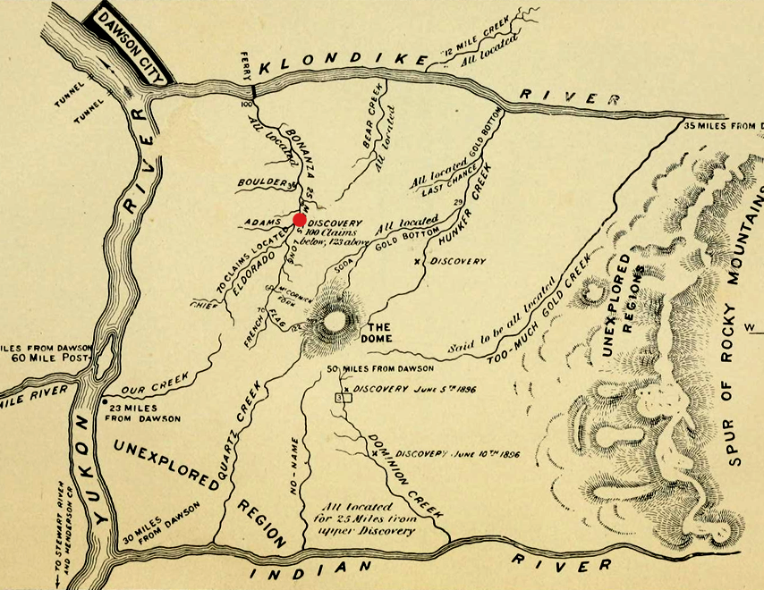
| Descriere | Map of Klondike River and gold bearing creeks, from an 1897 guidebook for gold seekers during the Klondike Gold Rush. Claimed and unexplored regions are marked[1] The gold flowed into the creeks from the dome in the middle.[2] Bonanza is the creek closest to Dawson City and discovery claim is in the middle of it |
| Dată | |
| Sursă | |
| Autor |
|
| Această imagine a fost retușată, ceea ce înseamnă că a fost modificată pe cale digitală și este diferită de cea inițială. Modificări: png (from original book), levels, crop, rotate. Imaginea inițială poate fi consultată aici: Klondike Gold Rush map.jpg. Modificările au fost efectuate de către Borrow-188.
|
This Canadian work is in the public domain in Canada because its copyright has expired due to one of the following:
it was not subject to Crown copyright, and
|
 |
References
Jurnalul original al încărcărilor
This image is a derivative work of the following images:
- File:Klondike_Gold_Rush_map.jpg licensed with PD-Canada
- 2010-03-02T20:15:43Z Zanka 944x602 (101938 Bytes) {{Information |Description= The Klondike Gold Field from the book "Klondike. The Chicago Record's book for gold seekers (1897)" p.14 |Source=http://www.archive.org/details/klondikechicagor00chic |Date=1897 |Author=unknown |Pe
Uploaded with derivativeFX
Istoricul fișierului
Apăsați pe Data și ora pentru a vedea versiunea trimisă atunci.
| Data și ora | Miniatură | Dimensiuni | Utilizator | Comentariu | |
|---|---|---|---|---|---|
| actuală | 4 ianuarie 2014 16:26 | | 854x660 (859 KB) | Soerfm | Red dot |
| 22 august 2011 17:51 |  | 854x662 (870 KB) | Soerenfm | Cropped in either end | |
| 21 august 2011 21:19 |  | 1.000x662 (958 KB) | Soerenfm | Enhange contrast | |
| 23 decembrie 2010 17:01 |  | 3.013x2.033 (1,66 MB) | Borrow-188 | {{Information |Description=The Klondike Gold Field from the book "Klondike. The Chicago Record's book for gold seekers (1897)" p.14 |Source=*File:Klondike_Gold_Rush_map.jpg |Date=2010-12-23 14:00 (UTC) |Author=*File:Klondike_Gold_Rush_map.jpg: |
Utilizarea fișierului
Următoarele pagini conțin această imagine:
Utilizarea globală a fișierului
Următoarele alte proiecte wiki folosesc acest fișier:
- Utilizare la en.wikipedia.org
- Utilizare la ru.wikipedia.org
- Utilizare la tr.wikipedia.org
- Utilizare la uk.wikipedia.org