
Fișier:Concord Expedition and Patriot Messengers.jpg

Mărimea acestei previzualizări: 800 × 341 pixeli. Alte rezoluții: 320 × 136 pixeli | 1.000 × 426 pixeli.
Mărește rezoluția imaginii (1.000 × 426 pixeli, mărime fișier: 139 KB, tip MIME: image/jpeg)
| Acest fișier se află la Wikimedia Commons. Consultați pagina sa descriptivă acolo. |

|
Acest fișier a fost înlocuit cu File:Concord Expedition and Patriot Messengers-en.svg. Se recomandă folosirea celuilalt fișier. Notă: Acest fișier nu va fi șters decât prin cererea explicită în cadrul nominalizărilor pentru ștergere.
|

|
O versiune vectorială a acestei imagini (SVG) este disponibilă.
Aceasta ar trebui folosită în locul vechii imagini pentru o afișare mai bună la rezoluții mari. File:Concord Expedition and Patriot Messengers.jpg → File:Concord Expedition and Patriot Messengers-en.svg
Pentru mai multe informații despre imaginile vectoriale, consultați pagina Commons transition to SVG. Vedeți, de asemenea, și informațiile despre modul în care software-ul MediaWiki acceptă imagini în format SVG. |
 |
Descriere fișier
| Titlu |
engleză:
Routes of the British Expedition and the Patriot Messengers |
||||||||||||||||||||
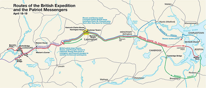
| Descriere |
Paul Revere's Midnight Ride English: This is a map depiction the outbound routes taken by Patriot riders and British troops in the Battles of Lexington and Concord on April 19, 1775. |
||||||||||||||||||||
| Map legend |
British route to Concord Revere's route Dawes' route Prescott's route |
||||||||||||||||||||
| Dată | Dată necunoscută; source PDF was created in 2000 | ||||||||||||||||||||
| Sursă | MIMAmap2.pdf 10 mai 2005 (upload date) de w:Flying Jazz (discuție | contribuții) | ||||||||||||||||||||
| Creator |
Necunoscut for National Park Service |
||||||||||||||||||||
| Geotemporal data | |||||||||||||||||||||
| Momentul de timp reprezentat | |||||||||||||||||||||
| Map location | Boston, Massachusetts | ||||||||||||||||||||
| Map type | thematic map | ||||||||||||||||||||
| Heading |
 |
||||||||||||||||||||
| Georeferencing | If inappropriate please set warp_status = skip to hide. | ||||||||||||||||||||
| Bibliographic data | |||||||||||||||||||||
| Editură |
National Park Service |
||||||||||||||||||||
| Archival data | |||||||||||||||||||||
| Colecție |
|
||||||||||||||||||||
| Inscripții |
Titlu : Routes of the British Expedition and the Patriot Messengers
Text :
Revere and Dawes reach Lexington before British leave Lechmere Point. Dr. Prescott joins them after they leave for Concord.
Text :
British patrol stops Revere, Dawes, and Prescott. Revere is captured, Dawes flees back to Lexington, and Prescott escapes to continue to Concord and beyond.
|
||||||||||||||||||||
| Alte versiuni |
|
||||||||||||||||||||


Licențiere
| This image or media file contains material based on a work of a National Park Service employee, created as part of that person's official duties. As a work of the U.S. federal government, such work is in the public domain in the United States. See the NPS website and NPS copyright policy for more information. |
Jurnalul original al încărcărilor
Transferred from en.wikipedia to Commons by Andrei Stroe using CommonsHelper.
Pagina originală de descriere a fost aici. Toate numele de utilizator de mai jos sunt pentru en.wikipedia.
- 2005-05-10 09:58 Flying Jazz 1000×426× (141988 bytes) Routes of the British Expedition and the Patriot Messengers April 18-19 (1775) Minute Man National Historical Park Battle Map http://data2.itc.nps.gov/parks/mima/ppMaps/MIMAmap2.pdf {{PD-USGov-Interior-NPS}}
- 2005-05-10 09:54 Flying Jazz 1000×426× (141988 bytes) Minute Man National Historical Park Battle Map http://data2.itc.nps.gov/parks/mima/ppMaps/MIMAmap2.pdf {{PD-USGov-Interior-NPS}}
Istoricul fișierului
Apăsați pe Data și ora pentru a vedea versiunea trimisă atunci.
| Data și ora | Miniatură | Dimensiuni | Utilizator | Comentariu | |
|---|---|---|---|---|---|
| actuală | 22 noiembrie 2010 23:50 | | 1.000x426 (139 KB) | File Upload Bot (Magnus Manske) | {{BotMoveToCommons|en.wikipedia|year={{subst:CURRENTYEAR}}|month={{subst:CURRENTMONTHNAME}}|day={{subst:CURRENTDAY}}}} {{Information |Description={{en|This is a map depiction the outbound routes taken by Patriot ride |
Utilizarea fișierului
Următoarele pagini conțin această imagine:
Utilizarea globală a fișierului
Următoarele alte proiecte wiki folosesc acest fișier:
- Utilizare la azb.wikipedia.org
- Utilizare la cs.wikipedia.org
- Utilizare la en.wikipedia.org
- Utilizare la fr.wikipedia.org
- Utilizare la it.wikipedia.org
- Utilizare la ru.wikipedia.org
- Utilizare la th.wikipedia.org
- Utilizare la zh.wikipedia.org