
Fișier:Venus clouds Galileo FalseColor PIA00112.jpg

Mărimea acestei previzualizări: 600 × 600 pixeli. Alte rezoluții: 240 × 240 pixeli | 480 × 480 pixeli | 1.000 × 1.000 pixeli.
Mărește rezoluția imaginii (1.000 × 1.000 pixeli, mărime fișier: 108 KB, tip MIME: image/jpeg)
| Acest fișier se află la Wikimedia Commons. Consultați pagina sa descriptivă acolo. |
Descriere fișier
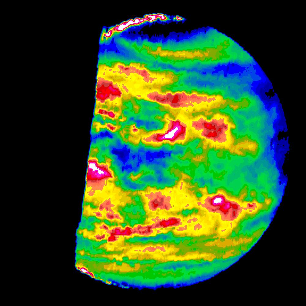
| Descriere | This image is a false color version of a near infrared map of lower level clouds on the night side of Venus, obtained by the Near Infrared Mapping Spectrometer aboard the Galileo spacecraft as it approached the planet February 10, 1990. Taken from an altitude of about 60,000 miles above the planet, at an infrared wavelength of 2.3 microns (about three times the longest wavelength visible to the human eye) the map shows the turbulent, cloudy middle atmosphere some 30-33 miles above the surface, 6-10 miles below the visible cloudtops. The image shows the radiant heat from the lower atmosphere (about 400 degrees Fahrenheit) shining through the sulfuric acid clouds, which appear as much as 10 times darker than the bright gaps between clouds. The colors indicate relative cloud transparency; white and red show thin cloud regions, while black and blue represent relatively thick clouds. This cloud layer is at about 30 degrees Fahrenheit, at a pressure about 1/2 Earth's atmospheric pressure. 2/3 of the dark hemisphere is visible, centered on longitude 350 West, with bright slivers of daylit high clouds visible at top and bottom left. Near the equator, the clouds appear fluffy and blocky; farther north, they are stretched out into East West filaments by winds estimated at more than 150 mph, while the poles are capped by thick clouds at this altitude. The Near Infrared Mapping Spectrometer (NIMS) on the Galileo spacecraft is a combined mapping (imaging) and spectral instrument. It can sense 408 contiguous wavelengths from 0.7 microns (deep red) to 5.2 microns, and can construct a map or image by mechanical scanning. It can spectroscopically analyze atmospheres and surfaces and construct thermal and chemical maps. Designed and operated by scientists and engineers at the Jet Propulsion Laboratory, NIMS involves 15 scientists in the U.S., England, and France. The Galileo Project is managed for NASA's Office of Space Science and Applications by JPL; its mission is to study the planet Jupiter and its satellites and magnetosphere after multiple gravity assist flybys at Venus and the Earth. |
| Dată | |
| Sursă | |
| Autor | NASA |
This image or video was catalogued by Jet Propulsion Laboratory of the United States National Aeronautics and Space Administration (NASA) under Photo ID: PIA00112. This tag does not indicate the copyright status of the attached work. A normal copyright tag is still required. See Commons:Licensing. Other languages:
|
Licențiere
| Acest fişier este în domeniul public fiindcă a fost creat de NASA. Politica drepturilor de autor a NASA spune că „Materialul NASA nu este protejat de dreptul de autor atâta timp cât nu se precizează altfel”. (NASA copyright policy page sau JPL Image Use Policy). | ||
 |
Atenţie:
|
Istoricul fișierului
Apăsați pe Data și ora pentru a vedea versiunea trimisă atunci.
| Data și ora | Miniatură | Dimensiuni | Utilizator | Comentariu | |
|---|---|---|---|---|---|
| actuală | 11 ianuarie 2008 16:34 | | 1.000x1.000 (108 KB) | Ruslik0 | {{Information |Description=This image is a false color version of a near infrared map of lower level clouds on the night side of Venus, obtained by the Near Infrared Mapping Spectrometer aboard the Galileo spacecraft as it approached the planet February 1 |
Utilizarea fișierului
Următoarele pagini conțin această imagine:
Utilizarea globală a fișierului
Următoarele alte proiecte wiki folosesc acest fișier:
- Utilizare la pl.wikipedia.org