
Fișier:Tannenberg3008.jpg
Mărimea acestei previzualizări: 775 × 600 pixeli. Alte rezoluții: 310 × 240 pixeli | 620 × 480 pixeli | 993 × 768 pixeli | 1.242 × 961 pixeli.
Mărește rezoluția imaginii (1.242 × 961 pixeli, mărime fișier: 207 KB, tip MIME: image/jpeg)
| Acest fișier se află la Wikimedia Commons. Consultați pagina sa descriptivă acolo. |

|
O versiune vectorială a acestei imagini (SVG) este disponibilă.
Aceasta ar trebui folosită în locul vechii imagini pentru o afișare mai bună la rezoluții mari. File:Tannenberg3008.jpg → File:East Prussian Campaign (27—30 Aug 1914) - ru.svg
Pentru mai multe informații despre imaginile vectoriale, consultați pagina Commons transition to SVG. Vedeți, de asemenea, și informațiile despre modul în care software-ul MediaWiki acceptă imagini în format SVG. |
_-_ru.svg) |
| Descriere |
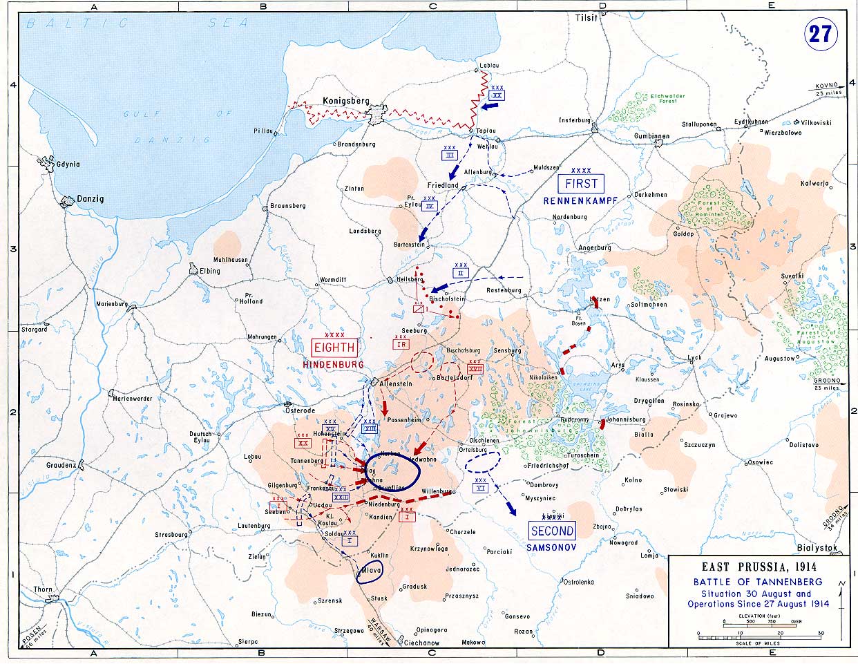
English: Battle of Tannenberg (1914) in its last phase |
| Sursă |
Taken from the campaign series, made public by the US-Army under dean.usma.edu
|
| Autor | US-Army under www.dean.usma.edu |
| Permisiune (Reutilizarea acestui fișier) |
The picture is public domain. |
This file is a work of a U.S. Army soldier or employee, taken or made as part of that person's official duties. As a work of the U.S. federal government, it is in the public domain in the United States.
|
 |
Istoricul fișierului
Apăsați pe Data și ora pentru a vedea versiunea trimisă atunci.
| Data și ora | Miniatură | Dimensiuni | Utilizator | Comentariu | |
|---|---|---|---|---|---|
| actuală | 22 septembrie 2005 17:29 | | 1.242x961 (207 KB) | Nasiruddin | Taken from the campaign series, made public by the US-Army under www.dean.usma.edu The öpicture is public domain. It shows the battle of Tannenberg in its last phase {{PD-USGov-Military-Army}} Category:World War I maps |
Utilizarea fișierului
Nicio pagină nu se leagă la această imagine.
Utilizarea globală a fișierului
Următoarele alte proiecte wiki folosesc acest fișier:
- Utilizare la be-tarask.wikipedia.org
- Utilizare la be.wikipedia.org
- Utilizare la ca.wikipedia.org
- Utilizare la cs.wikipedia.org
- Utilizare la da.wikipedia.org
- Utilizare la de.wikipedia.org
- Utilizare la el.wikipedia.org
- Utilizare la en.wikipedia.org
- Utilizare la et.wikipedia.org
- Utilizare la fi.wikipedia.org
- Utilizare la fr.wikipedia.org
- Utilizare la he.wikipedia.org
- Utilizare la hr.wikipedia.org
- Utilizare la it.wikipedia.org
- Utilizare la ja.wikipedia.org
- Utilizare la ko.wikipedia.org
- Utilizare la lv.wikipedia.org
- Utilizare la nl.wikipedia.org
- Utilizare la no.wikipedia.org
- Utilizare la pl.wikipedia.org
- Utilizare la sv.wikipedia.org
- Utilizare la uk.wikipedia.org
- Utilizare la vi.wikipedia.org
- Utilizare la zh.wikipedia.org