
Fișier:Schlieffen Plan.jpg

Mărește rezoluția imaginii (963 × 745 pixeli, mărime fișier: 732 KB, tip MIME: image/jpeg)
| Acest fișier se află la Wikimedia Commons. Consultați pagina sa descriptivă acolo. |

|
O versiune vectorială a acestei imagini (SVG) este disponibilă.
Aceasta ar trebui folosită în locul vechii imagini pentru o afișare mai bună la rezoluții mari. File:Schlieffen Plan.jpg → File:Schlieffen Plan fr.svg
Pentru mai multe informații despre imaginile vectoriale, consultați pagina Commons transition to SVG. Vedeți, de asemenea, și informațiile despre modul în care software-ul MediaWiki acceptă imagini în format SVG. |
 |
| Descriere |
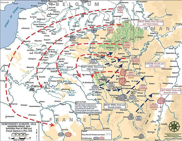
English: Schlieffen Plan
In 1938 the predecessors of what is today The Department of History at the United States Military Academy began developing a series of campaign atlases to aid in teaching cadets a course entitled, "History of the Military Art." Since then, the Department has produced over six atlases and more than one thousand maps, encompassing not only America’s wars but global conflicts as well. In keeping abreast with today's technology, the Department of History is providing these maps on the internet as part of the department's outreach program. The maps were created by the United States Military Academy’s Department of History and are the digital versions from the atlases printed by the United States Defense Printing Agency. We gratefully acknowledge the accomplishments of the department's former cartographer, Mr. Edward J. Krasnoborski, along with the works of our present cartographer, Mr. Frank Martini. Please be aware that these maps are large in file size and may require substantial download times. |
| Dată | 05/09/2008 |
| Sursă | Westpoint.edu, WWI Atlas, Shlieffen Plan |
| Autor | Tinodela |
| Alte versiuni |
|
This file is a work of a U.S. Army soldier or employee, taken or made as part of that person's official duties. As a work of the U.S. federal government, it is in the public domain in the United States.
|
 |
Derivative works
Creații derivate din acest fișier: Schlieffen Plan.svg
Istoricul fișierului
Apăsați pe Data și ora pentru a vedea versiunea trimisă atunci.
| Data și ora | Miniatură | Dimensiuni | Utilizator | Comentariu | |
|---|---|---|---|---|---|
| actuală | 23 iulie 2012 14:43 | | 963x745 (732 KB) | Soerfm | Paris |
| 1 martie 2006 14:58 |  | 969x751 (273 KB) | W.wolny |
Utilizarea fișierului
Următoarele pagini conțin această imagine:
Utilizarea globală a fișierului
Următoarele alte proiecte wiki folosesc acest fișier:
- Utilizare la ar.wikipedia.org
- Utilizare la be-tarask.wikipedia.org
- Utilizare la be.wikipedia.org
- Utilizare la bg.wikipedia.org
- Utilizare la ca.wikipedia.org
- Utilizare la cs.wikipedia.org
- Utilizare la da.wikipedia.org
- Utilizare la de.wikipedia.org
- Utilizare la de.wikibooks.org
- Utilizare la de.wikinews.org
- Utilizare la el.wikipedia.org
- Utilizare la en.wikipedia.org
- Utilizare la en.wikibooks.org
- Utilizare la fi.wikipedia.org
- Utilizare la fr.wikipedia.org
Vizualizați utilizările globale ale acestui fișier.