
Fișier:Plan Nicholsona.jpg
Mărește rezoluția imaginii (6.092 × 4.849 pixeli, mărime fișier: 8,25 MB, tip MIME: image/jpeg)
| Acest fișier se află la Wikimedia Commons. Consultați pagina sa descriptivă acolo. |
Descriere fișier
| Autor |
Drawn by
|
|||||||||||||||||||||||
| Descriere |
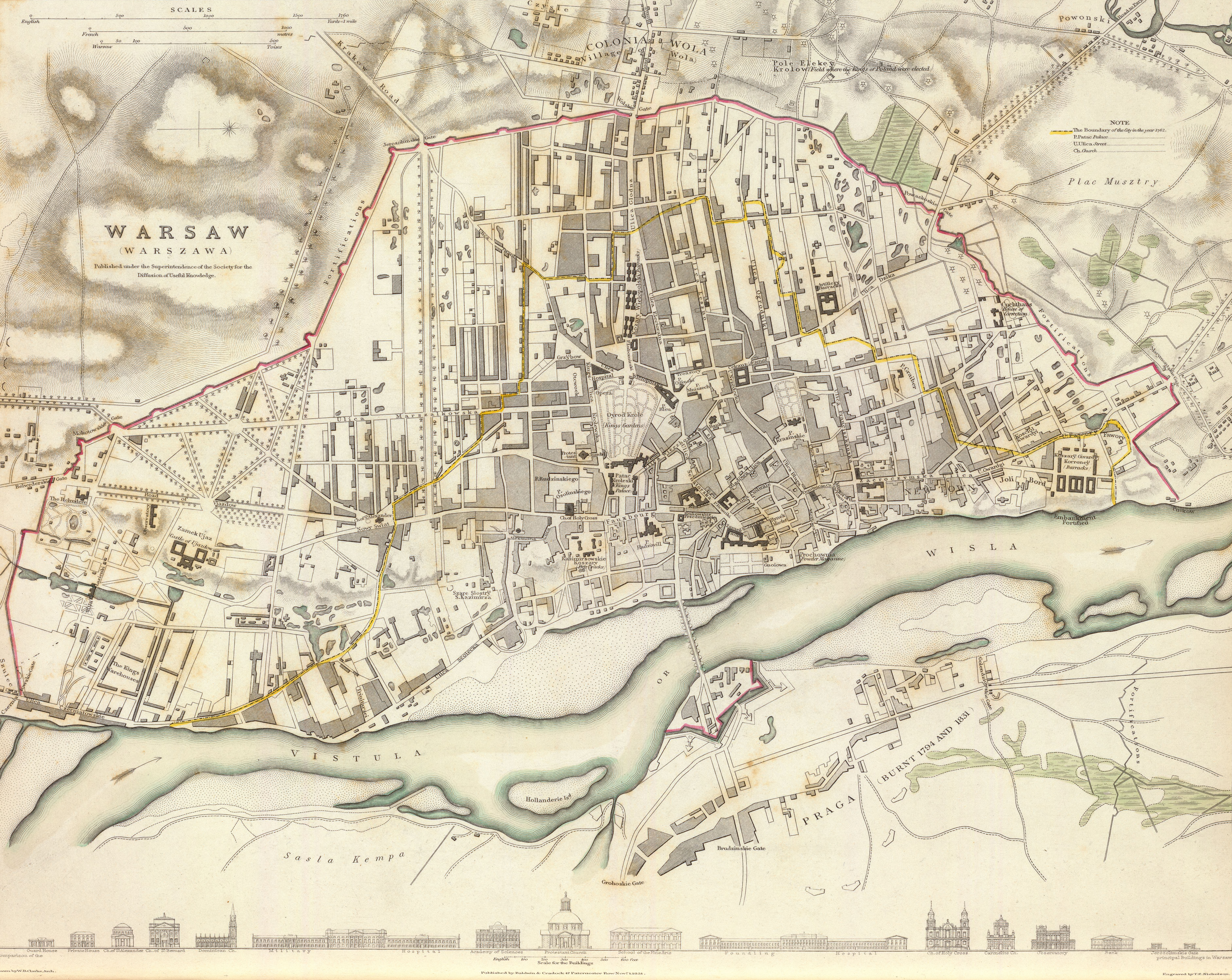
English: 1831 map of Warsaw, Poland, the so-called "Nicholson's Plan"
Note that the map is neither very accurate in terms of precision [1] nor in proper place names. Many if not most have been misspelt (Oyrod Krole park should be Ogród Królewski, Kozary Wielopolski (six buildings to the north of the park) should be called Koszary Wielopolskie, Cekauz (Arsenal) => Cekhauz, Patac Kroleski => Pałac Królewski and so on). Downloaded from David Rumsey's site ([2]), converted from .sid to .tiff format with mrsidgeodecode and then to .jpg with Adobe PS.Polski: Plan Warszawy z roku 1831, tzw. Plan Nicholsona
Plan jest względnie niedokładny, zarówno jeśli chodzi o precyzję jak i nazwy własne[3]. Wiele z nich zostało przekręconych (na przykład "Oyrod Krole" zamiast "Ogród Królewski", "Kozary Wielopolski" w miejsce "Koszarów Wielopolskich", "Cekauz" zamiast "Cekhauz", "Patac Kroleski" zamiast "Pałac Królewski" itd.). Mapa pobrana ze strony Davida Rumseya ([4]), przekonwertowana z formatu .sid do .tiff za pomocą mrsidgeodecode, a następnie do formatu .jpg z użyciem Adobe Photoshop. |
|||||||||||||||||||||||
| Dată | 1 noiembrie 1831 | |||||||||||||||||||||||
| Mediu | gravură | |||||||||||||||||||||||
| Dimensiuni | Înălțime: 30 cm; lățime: 38 cm | |||||||||||||||||||||||
| Inscripții | Published under the superintendence of the Society for the Diffusion of Useful Knowledge. Drawn by W.B. Clarke, archt. Engraved by T.E. Nicholson. Published by Baldwin & Cradock, 47 Paternoster Row, Novr. 1, 1831. (London: Chapman & Hall, 1844) | |||||||||||||||||||||||
| Sursă/Fotograf | [5] | |||||||||||||||||||||||
| Alte versiuni |
|
|||||||||||||||||||||||

Licențiere
|
Această lucrare este, de asemenea, în domeniul public în ţările şi zonele în care durata drepturilor de autor este viaţa autorului plus 100 de ani sau mai puţin. | |
| Acest fișier a fost identificat ca fiind liber de orice restricții cunoscute privind legea drepturilor de autor, inclusiv toate drepturile conexe sau înrudite. | |
This work is in the public domain in the United States because it was published (or registered with the U.S. Copyright Office) before January 1, 1929.
Public domain works must be out of copyright in both the United States and in the source country of the work in order to be hosted on the Commons. If the work is not a U.S. work, the file must have an additional copyright tag indicating the copyright status in the source country.
Note: This tag should not be used for sound recordings. |
| Annotations | This image is annotated: View the annotations at Commons |
Istoricul fișierului
Apăsați pe Data și ora pentru a vedea versiunea trimisă atunci.
| Data și ora | Miniatură | Dimensiuni | Utilizator | Comentariu | |
|---|---|---|---|---|---|
| actuală | 18 septembrie 2011 02:30 | | 6.092x4.849 (8,25 MB) | Halibutt |
Utilizarea fișierului
Următoarele pagini conțin această imagine:
Utilizarea globală a fișierului
Următoarele alte proiecte wiki folosesc acest fișier:
- Utilizare la azb.wikipedia.org
- Utilizare la en.wikipedia.org
- Utilizare la nl.wikipedia.org
- Utilizare la pl.wikipedia.org
- Utilizare la ru.wikipedia.org
- Utilizare la uk.wikipedia.org
- Utilizare la vi.wikipedia.org