
Fișier:Occupied Palestinian Territories.jpg

Mărimea acestei previzualizări: 393 × 599 pixeli. Alte rezoluții: 157 × 240 pixeli | 315 × 480 pixeli | 504 × 768 pixeli | 672 × 1.024 pixeli | 1.895 × 2.889 pixeli.
Mărește rezoluția imaginii (1.895 × 2.889 pixeli, mărime fișier: 949 KB, tip MIME: image/jpeg)
| Acest fișier se află la Wikimedia Commons. Consultați pagina sa descriptivă acolo. |
Descriere fișier
| Descriere |
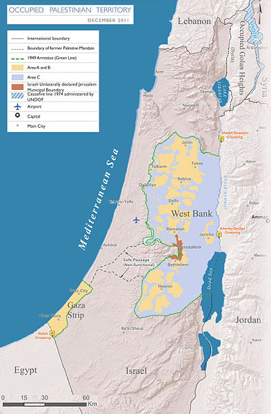
English: Map of the Occupied Palestinian Territories (West Bank and Gaza Strip), marked by the Green Line. Based on Reference Map: occupied Palestinian territory: Overview Map, as of December 2011. Published by United Nations Office for the Coordination of Humanitarian Affairs (OCHAoPt), 25 January 2012
العربية: خريطة للأراضي الفلسطينية المحتلة (الضفة الغربية وقطاع غزة) ، مميزة بالخط الأخضر. استنادًا إلى الخريطة المرجعية: "الأراضي الفلسطينية المحتلة: خريطة عامة" ، اعتبارًا من ديسمبر 2011. تم النشر بواسطة مكتب الأمم المتحدة لتنسيق الشؤون الإنسانية (OCHAoPt ) ، 25 يناير 2012 |
| Dată | |
| Sursă | Operă proprie, based on http://www.ochaopt.org/documents/ochaopt_atlas_opt_general_december2011.pdf on [1] |
| Autor | Wickey-nl |

|
Imaginile din această galerie trebuie recreat(ă/e) sub format vectorial ca fișier SVG. Acest format are mai multe avantaje; vezi Commons:Media for cleanup pentru mai multe informații. Dacă deja este disponibilă o versiune SVG a acestei imagini, vă rugăm să o încărcați. După încărcarea pe serverele Commons a versiunii SVG, înlocuiți acest format cu formatul {{vector version available|noul nume al imaginii.svg}}.
|


Licențiere
Eu, deținătorul drepturilor de autor ale acestei opere, prin prezenta îmi public lucrarea sub următoarea licență:
Acest fișier a fost eliberat sub licența Creative Commons Atribuire și distribuire în condiții identice 3.0 Neadaptată.
- Sunteți liber:
- să partajați cu alții – aveți dreptul de a copia, distribui și transmite opera
- să adaptați – aveți dreptul de a adapta opera
- În următoarele condiții:
- atribuind – Trebuie să atribuiți opera corespunzător, introducând o legătură către licență și indicând dacă ați făcut schimbări. Puteți face asta prin orice metodă rezonabilă, dar nu într-un fel care ar sugera faptul că persoana ce a licențiat conținutul v-ar susține sau ar aproba folosirea de către dumneavoastră a operei sale.
- partajând în condiții identice – Dacă modificați, transformați sau creați pe baza acestei opere, trebuie să distribuiți opera rezultată doar sub aceeași licență sau sub o licență similară acesteia.

Istoricul fișierului
Apăsați pe Data și ora pentru a vedea versiunea trimisă atunci.
| Data și ora | Miniatură | Dimensiuni | Utilizator | Comentariu | |
|---|---|---|---|---|---|
| actuală | 25 martie 2014 20:08 | | 1.895x2.889 (949 KB) | Wickey-nl | User created page with UploadWizard |
Utilizarea fișierului
Nicio pagină nu se leagă la această imagine.
Utilizarea globală a fișierului
Următoarele alte proiecte wiki folosesc acest fișier:
- Utilizare la af.wikipedia.org
- Utilizare la ar.wikipedia.org
- Utilizare la az.wikipedia.org
- Utilizare la bh.wikipedia.org
- Utilizare la bn.wikipedia.org
- Utilizare la bug.wikipedia.org
- Utilizare la cs.wikipedia.org
- Utilizare la da.wikipedia.org
- Utilizare la de.wikipedia.org
- Utilizare la el.wikipedia.org
- Utilizare la en.wikipedia.org
- Israeli–Palestinian conflict
- Palestinian territories
- Israeli-occupied territories
- Frozen conflict
- United Nations Security Council Resolution 1515
- Talk:Israeli–Palestinian conflict/Archive 18
- United States involvement in regime change
- Boycott, Divestment and Sanctions
- Two-state solution
- Talk:State of Palestine/Archive 12
- Freedom of religion in Asia by country
- User:Falcaorib
- From the river to the sea
- User:Christophervincent01
- Utilizare la es.wikipedia.org
- Utilizare la et.wikipedia.org
- Utilizare la fa.wikipedia.org
- Utilizare la fi.wikipedia.org
- Utilizare la fy.wikipedia.org
- Utilizare la gl.wikipedia.org
- Utilizare la he.wikipedia.org
- Utilizare la hu.wikipedia.org
- Utilizare la id.wikipedia.org
- Utilizare la io.wikipedia.org
- Utilizare la it.wikipedia.org
- Utilizare la ja.wikipedia.org
- Utilizare la la.wikipedia.org
Vizualizați utilizările globale ale acestui fișier.