
Fișier:Map of Eagle County, Colorado.png
Mărește rezoluția imaginii (3.265 × 2.571 pixeli, mărime fișier: 56 KB, tip MIME: image/png)
| Acest fișier se află la Wikimedia Commons. Consultați pagina sa descriptivă acolo. |
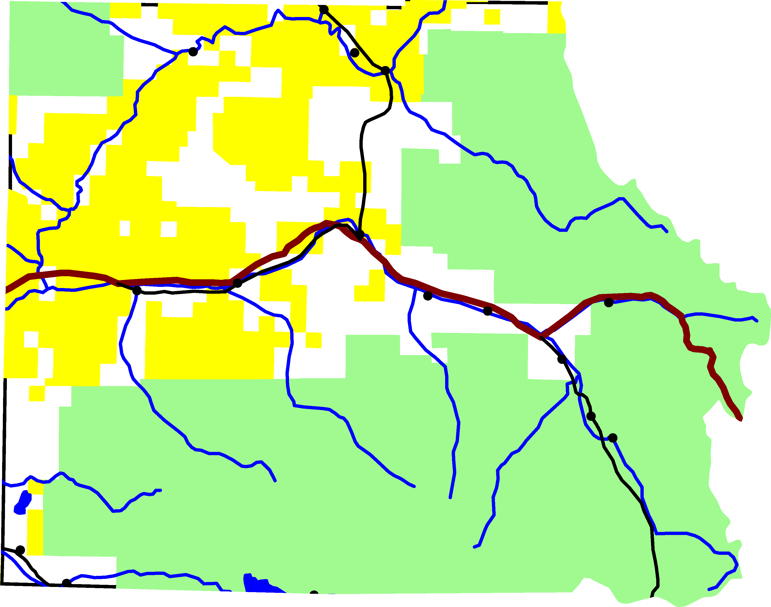
A map of Eagle County, Colorado. Green is White River National Forest, yellow is Bureau of Land Management land. The reddish line from east to west is Interstate 70. The black lines are roads. In the southeastern quadrant is U.S. Highway 24. In the north-central is Colorado State Highway 131. Running along I-70 is U.S. Highway 6. And in the south-west corner is Colorado State Highway 82.
For scale, the county is about 50 miles wide.
The lake on the southern border is Ruedi Reservior, with Fryingpan River. Gore Creek is the easternmost river on the map. It joins the Eagle River, which starts in the south-east corner of the county and flows north-west until it joins I-70. The river in the northern half of the county is the Colorado River.
David Benbennick made this map from data at nationalatlas.gov. The data is accurate to 0.000278 degrees, or about 65 feet.
| Eu, deținătorul drepturilor de autor ale acestei opere, o eliberez domeniului public. Aceasta se aplică în întreaga lume. În anumite țări există posibilitatea ca acest lucru să nu fie legal posibil; în acest caz: permit oricui să utilizeze această operă în orice scop, fără nicio condiție, atâta timp cât asemenea condiții nu sunt cerute de lege. |
Istoricul fișierului
Apăsați pe Data și ora pentru a vedea versiunea trimisă atunci.
| Data și ora | Miniatură | Dimensiuni | Utilizator | Comentariu | |
|---|---|---|---|---|---|
| actuală | 7 august 2005 01:23 | | 3.265x2.571 (56 KB) | Dbenbenn | lighter green for national forest, #A0F090, taken from w:Wikipedia talk:WikiProject Maps |
| 2 august 2005 19:01 |  | 3.265x2.571 (56 KB) | Dbenbenn | put county boundary underneath everything else. More accurate display at border. | |
| 1 august 2005 19:15 |  | 3.265x2.571 (58 KB) | Dbenbenn | by me, PD |
Utilizarea fișierului
Următoarele pagini conțin această imagine:
Utilizarea globală a fișierului
Următoarele alte proiecte wiki folosesc acest fișier:
- Utilizare la en.wikipedia.org
- Utilizare la es.wikipedia.org
- Utilizare la ja.wikipedia.org