
Fișier:Manhattanhenge satellite view.svg

Mărimea acestei previzualizări PNG a acestui fișier SVG: 400 × 600 pixeli. Alte rezoluții: 160 × 240 pixeli | 320 × 480 pixeli | 512 × 768 pixeli | 682 × 1.024 pixeli | 1.365 × 2.048 pixeli.
Mărește rezoluția imaginii (Fișier SVG, cu dimensiunea nominală de 512 × 768 pixeli, mărime fișier: 67 KB)
| Acest fișier se află la Wikimedia Commons. Consultați pagina sa descriptivă acolo. |

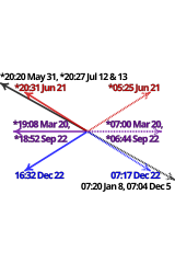
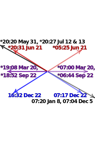
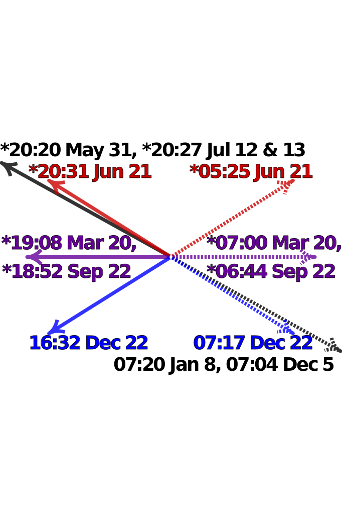
| Descriere | Satellite image of Manhattan, New York City centered on the intersection of Park Avenue and 34th Street, with directions and local times of sunrises (dotted lines) and sunsets (solid lines) on Manhattanhenge (black), summer solstice (red), equinoxes (purple) and winter solstice (blue) in 2011. Times marked with "*" have been adjusted for daylight saving. Data from http://www.esrl.noaa.gov/gmd/grad/solcalc/ and bitmap from http://earthobservatory.nasa.gov/IOTD/view.php?id=3678 and created by NASA. | |
| Dată | (UTC) | |
| Sursă |
|
|
| Autor |
|

W3C-validity not checked.

|
This SVG file contains embedded text that can be translated into your language, using any capable SVG editor, text editor or the SVG Translate tool. For more information see: About translating SVG files. |
| Această imagine a fost retușată, ceea ce înseamnă că a fost modificată pe cale digitală și este diferită de cea inițială. Modificări: Update to 2012 and reduce clutter. Imaginea inițială poate fi consultată aici: Manhattanhenge map.svg. Modificările au fost efectuate de către Cmglee.
|
Eu, deținătorul drepturilor de autor ale acestei opere, prin prezenta îmi public lucrarea sub următoarea licență:
Acest fișier a fost eliberat sub licența Creative Commons Atribuire și distribuire în condiții identice 3.0 Neadaptată.
- Sunteți liber:
- să partajați cu alții – aveți dreptul de a copia, distribui și transmite opera
- să adaptați – aveți dreptul de a adapta opera
- În următoarele condiții:
- atribuind – Trebuie să atribuiți opera corespunzător, introducând o legătură către licență și indicând dacă ați făcut schimbări. Puteți face asta prin orice metodă rezonabilă, dar nu într-un fel care ar sugera faptul că persoana ce a licențiat conținutul v-ar susține sau ar aproba folosirea de către dumneavoastră a operei sale.
- partajând în condiții identice – Dacă modificați, transformați sau creați pe baza acestei opere, trebuie să distribuiți opera rezultată doar sub aceeași licență sau sub o licență similară acesteia.
Jurnalul original al încărcărilor
This image is a derivative work of the following images:
- File:Manhattanhenge_map.svg licensed with Cc-by-sa-3.0
- 2011-07-18T23:55:44Z Cmglee 512x768 (71587 Bytes) Fix text.
- 2011-07-18T23:47:00Z Cmglee 512x768 (71599 Bytes) {{Information |Description=Map of Manhattan, New York City centered on the intersection of Park Avenue and 34th Street, with times and directions of sunrises (dotted line) and sunsets (solid line) in 2011. Times marked with "
Uploaded with derivativeFX
Istoricul fișierului
Apăsați pe Data și ora pentru a vedea versiunea trimisă atunci.
| Data și ora | Miniatură | Dimensiuni | Utilizator | Comentariu | |
|---|---|---|---|---|---|
| actuală | 30 iulie 2011 03:48 | | 512x768 (67 KB) | Cmglee | Bold text and arrows. |
| 30 iulie 2011 03:39 |  | 512x768 (67 KB) | Cmglee | Shrink text. | |
| 30 iulie 2011 03:38 |  | 512x768 (67 KB) | Cmglee | Use 2011 dates, darken purple text and enlarge text. | |
| 28 iulie 2011 07:38 |  | 512x768 (67 KB) | Cmglee | {{Information |Description=Satellite image of Manhattan, New York City centered on the intersection of Park Avenue and 34th Street, with directions and local times of sunrises (dotted lines) and sunsets (solid lines) on Manhattanhenge (black), summer sols |
Utilizarea fișierului
Următoarele pagini conțin această imagine:
Utilizarea globală a fișierului
Următoarele alte proiecte wiki folosesc acest fișier:
- Utilizare la en.wikipedia.org
- Utilizare la es.wikipedia.org
- Utilizare la fa.wikipedia.org
- Utilizare la id.wikipedia.org
- Utilizare la it.wikipedia.org
- Utilizare la ja.wikipedia.org
- Utilizare la ko.wikipedia.org
- Utilizare la ms.wikipedia.org
- Utilizare la pt.wikipedia.org
- Utilizare la www.wikidata.org
- Utilizare la zh.wikipedia.org