
Fișier:Carte de ukraine 1919.jpg

Mărimea acestei previzualizări: 800 × 508 pixeli. Alte rezoluții: 320 × 203 pixeli | 640 × 406 pixeli | 934 × 593 pixeli.
Mărește rezoluția imaginii (934 × 593 pixeli, mărime fișier: 305 KB, tip MIME: image/jpeg)
| Acest fișier se află la Wikimedia Commons. Consultați pagina sa descriptivă acolo. |
Descriere fișier
| Descriere |
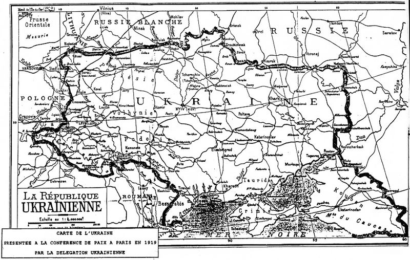
Deutsch: Grenzziehung der Ukrainischen Republik, wie sie von der ukrainischen Delegation auf der Pariser Friedenskonferenz 1919 präsentiert wurde
English: Map of Ukraine presented by Ukrainian delegation on Paris Peace Conference, 1919
Українська: Межі України, які були заявлені делегацією УНР на Паризькій мирній конференції в 1919-20 рр. |
| Dată | 1919 |
| Sursă | direct source:Documents of Paris Peace Conference 1919 see also :"Akten zur deutschen auswärtigen Politik 1918-1945" Ser. A, 1918-1925. Bd. 1, 9. November bis 5. Mai 1919 Göttingen : Vandenhoeck und Ruprecht, 1982. |
| Autor | Government of ZUNR in name of ZUNR and UNR, official document of government of Ukraine |
| Alte versiuni |
|


Licențiere
This file is a Ukrainian or Ukrainian SSR work and it is presently in the public domain in Ukraine, because it was published before January 1, 1954, and the creator (if known) died before that date (details).
|
 |
Istoricul fișierului
Apăsați pe Data și ora pentru a vedea versiunea trimisă atunci.
| Data și ora | Miniatură | Dimensiuni | Utilizator | Comentariu | |
|---|---|---|---|---|---|
| actuală | 2 octombrie 2011 03:48 | | 934x593 (305 KB) | Yerevanci | better version |
| 8 martie 2008 04:49 |  | 934x593 (194 KB) | Riwnodennyk | {{Information |Description={{en|Map of Ukraine perposed by Ukrainian delegation on Paris Peace Conference, 1919}} |Source=[http://uk.wikipedia.org/wiki/Зображення:Carte_de_ukraine_1919.jpg Ukrainian Wikipedia] |
Utilizarea fișierului
Nicio pagină nu se leagă la această imagine.
Utilizarea globală a fișierului
Următoarele alte proiecte wiki folosesc acest fișier:
- Utilizare la be-tarask.wikipedia.org
- Utilizare la et.wikipedia.org