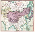
Fișier:1806 Cary Map of Tartary or Central Asia - Geographicus - Tartary-cary-1806.jpg

Conținutul paginii nu este suportat în alte limbi.
De la Wikipedia, enciclopedia liberă

Mărește rezoluția imaginii(5.000 × 4.569 pixeli, mărime fișier: 8,57 MB, tip MIME: image/jpeg)

Acest fișier se află la Wikimedia Commons. Consultați pagina sa descriptivă acolo.
John Cary: A New Map of Mongolian & Independent Tartary , From the Latest Authorities.   (Wikidata search (Cirrus search) Wikidata query (SPARQL)  Create new Wikidata item based on this file)
Artist
John Cary  (–1835)  wikidata:Q3446124 s:en:Author:John Cary
 
Nume alternative
J. Cary
Descriere cartograf, gravor, mapseller, printseller și grafician
Data nașterii/decesului 23 februarie 1755 / 1754 Modificați la Wikidata 16 august 1835 Modificați la Wikidata
Locul nașterii/decesului Corsley Mortlake
Perioada de lucru 1788 / 1793 / 1797 Modificați la Wikidata
Locul de lucru
Authority file
artist QS:P170,Q3446124
Titlu
A New Map of Mongolian & Independent Tartary , From the Latest Authorities.
Descriere
English: An exceptionally beautiful example of John Cary’s important 1806 map of Mongolian and Independent Tartary. Covers Central Asia from the Caspian Sea to Japan, extends as far north as the Obskaia Sea and as far south as India, Burma and the Philippines. Includes the modern day nations of Uzbekistan, Kazakhstan, Turkmenistan, Kirgizstan, Tajikistan and Mongolia. One of Cary’s most interesting maps. Central Asia, despite hundreds of years of passing trade on the Silk Routes, was still, at the turn of the century a largely unknown land. Cary attempts to show some of the Silk Route passages, especially to the north of the Gobi, but ultimately admits, “The Geography of these parts is extremely obscure.” All in all, one of the most interesting and few maps of Central Asia to appear in first years of the 19th century. Prepared in 1806 by John Cary for issue in his magnificent 1808 New Universal Atlas. (NOTE: The reproduction of the colors in this map appear to be incorrect, as Japan and Tibet were never part of Chinese Tartary yet appear to be the same color as it.)
Dată 1806 (dated)
Dimensiuni Înălțime: 18,5 țoli (46,9 cm); lățime: 20 țoli (50,8 cm)
dimensions QS:P2048,18.5U218593
dimensions QS:P2049,20U218593
Număr de inventar
Geographicus link: Tartary-cary-1806
Sursă/Fotograf

Cary, John, Cary's New Universal Atlas, containing distinct maps of all the principal states and kingdoms throughout the World. From the latest and best authorities extant. London: Printed for J. Cary, Engraver and Map-seller, No. 181, near Norfolk Street, Strand, 1808.

Permisiune
(Reutilizarea acestui fișier)
Această operă de artă bi-dimensională, redată în această imagine, este domeniu public în întreaga lume, datorită fie morții autorului, fie datei publicării acesteia.
Public domain

Această lucrare este, de asemenea, în domeniul public în ţările şi zonele în care durata drepturilor de autor este viaţa autorului plus 100 de ani sau mai puţin.


You must also include a United States public domain tag to indicate why this work is in the public domain in the United States.
Ca atare, această reproducere este, de asemenea, parte a domeniului public. (Cele de mai sus se aplică reproducerilor create în Statele Unite ale Americii, Germania și multe alte țări. Vedeți și articolul dedicat procesului Commons:Reuse of PD-Art photographs).
Alte versiuni
Annotations
InfoField
This image is annotated: View the annotations at Commons

Captions

Add a one-line explanation of what this file represents

Items portrayed in this file

subiectul reprezentat

image/jpeg

checksum engleză

3d7f1be3ae7a9539d26d91394bee37e7dc951779

8.990.511 byte

4.569 pixel

5.000 pixel

Istoricul fișierului

Apăsați pe Data și ora pentru a vedea versiunea trimisă atunci.

Data și oraMiniaturăDimensiuniUtilizatorComentariu
actuală19 august 2019 11:56Miniatură pentru versiunea din 19 august 2019 11:565.000x4.569 (8,57 MB)SoerfmBrightness, color
22 martie 2011 13:56Miniatură pentru versiunea din 22 martie 2011 13:565.000x4.569 (7,81 MB)BotMultichillT{{subst:User:Multichill/Geographicus |link=http://www.geographicus.com/P/AntiqueMap/Tartary-cary-1806 |product_name=1806 Cary Map of Tartary or Central Asia |map_title=A New Map of Chinese & Independent Tartary , From the Latest Authorities. |description=

Următoarele pagini conțin această imagine:

Utilizarea globală a fișierului

Următoarele alte proiecte wiki folosesc acest fișier:

Informații