
Fișier:Roman Empire Map AlexanderFindlay1849.png
Mărește rezoluția imaginii (2.038 × 1.828 pixeli, mărime fișier: 2 MB, tip MIME: image/png)
| Acest fișier se află la Wikimedia Commons. Consultați pagina sa descriptivă acolo. |
Descriere fișier
| Descriere |
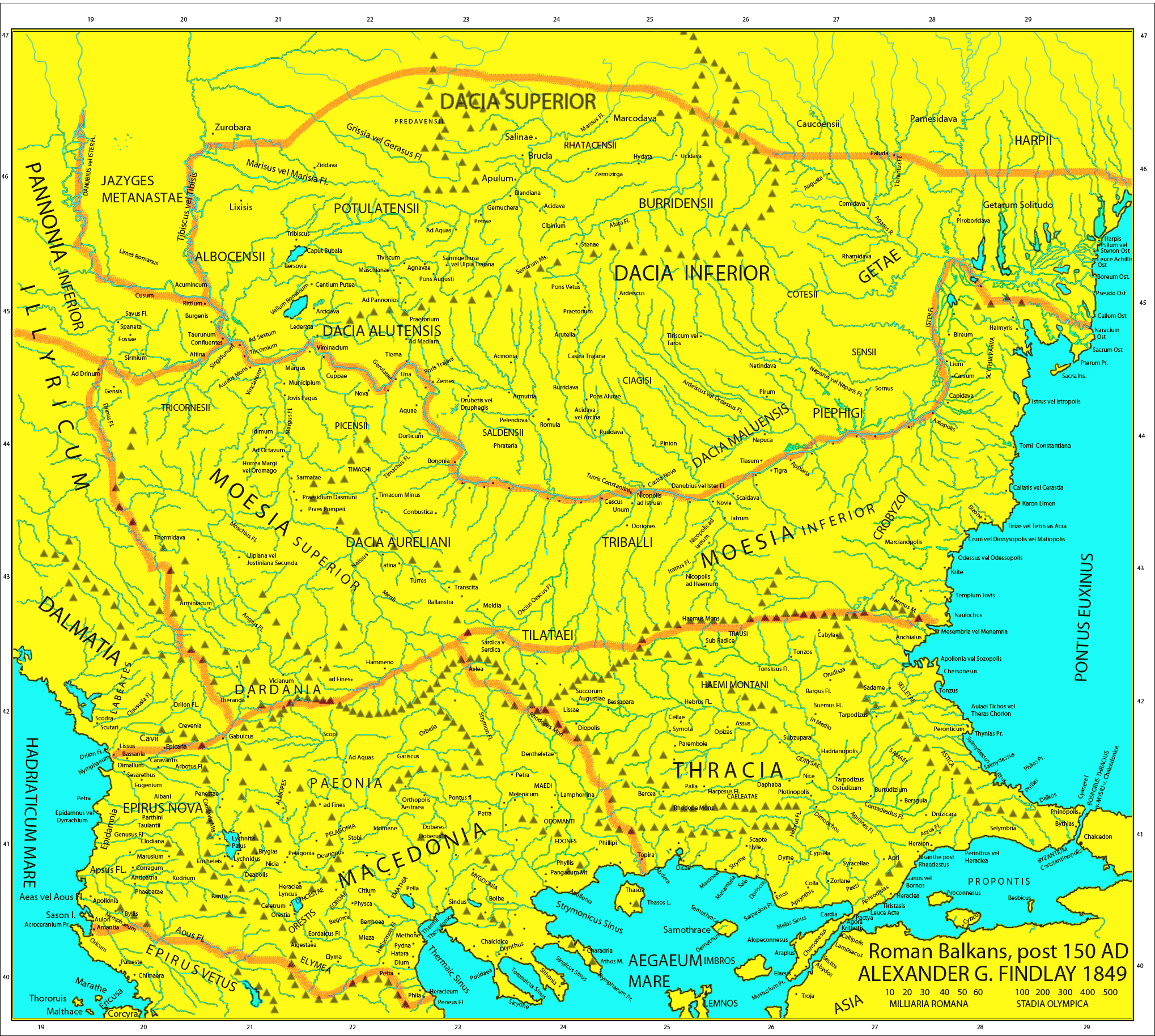
Map of the Roman provinces of Macedonia, Thracia, Illyricum, part of Pannonia Inferior, Moesia & Dacia. It is a reproduction of the 1849 Finley Map with Roman provincial borders (of about 150 AD) added to provide more information. This means that locations of many cities, tribes or other features are according to 1849 scholarship and not up to date. For example, many cities shown have not been identified yet and Findlay made arbirtrary conclusions. A great omission is that Lake Prespas are missing.
|
||
| Dată | |||
| Sursă |
A classical atlas, to illustrate ancient geography: comprised in twenty-five maps, showing the various divisions of the world as known to the ancients : composed from the most authentic sources with an index of the ancient and modern names,Alexander G. Findlay,Publisher;Harper,1849 (Macedonia, Thracia, Illyria, Moesia, Dacia),Map X,"Comment on Map from author; Map X., & c. - Although most portions of this map are well represented, still we have a deficiency in the classical portion, as it has not been yet sufficiently examined by those who are capable of deciding and systematizing the comparative geography."
|
||
| Autor | User:Megistias | ||
| Permisiune (Reutilizarea acestui fișier) |
|
||
| Alte versiuni |
   |
Istoricul fișierului
Apăsați pe Data și ora pentru a vedea versiunea trimisă atunci.
| Data și ora | Miniatură | Dimensiuni | Utilizator | Comentariu | |
|---|---|---|---|---|---|
| actuală | 5 mai 2019 18:44 | | 2.038x1.828 (2 MB) | Julieta39 | Regiones Porolissensis et Napocaoensis cum salinae et aurum excavationes |
| 24 septembrie 2017 17:05 |  | 2.038x1.677 (1,9 MB) | Julieta39 | Orthographic correction (alutensis, not alupensis and superior, not superirior) | |
| 5 noiembrie 2015 23:04 |  | 2.038x1.677 (1,9 MB) | Spiridon Ion Cepleanu | Easier colours for reading the place names | |
| 25 februarie 2010 20:30 |  | 2.038x1.677 (1,8 MB) | Megistias | == {{int:filedesc}} == {{Information |Description=Map of the Roman provinces of Macedonia, Thracia, Illyricum, part of Pannonia Inferior, Moesia & Dacia. It is a reproduction of the 1849 Finley Map with Roman provincial borders (of about 150 AD) added to |
Utilizarea fișierului
Următoarele pagini conțin această imagine:
Utilizarea globală a fișierului
Următoarele alte proiecte wiki folosesc acest fișier:
- Utilizare la el.wikipedia.org
- Utilizare la en.wikipedia.org
- Utilizare la fr.wikipedia.org
- Utilizare la la.wikipedia.org
- Utilizare la nl.wikipedia.org
- Utilizare la pt.wikipedia.org
- Utilizare la uk.wikipedia.org