
Fișier:MSH80 mudline muddy river with USGS scientist 10-23-80.jpg

Mărimea acestei previzualizări: 800 × 536 pixeli. Alte rezoluții: 320 × 215 pixeli | 640 × 429 pixeli | 1.024 × 687 pixeli | 1.280 × 858 pixeli | 2.904 × 1.947 pixeli.
Mărește rezoluția imaginii (2.904 × 1.947 pixeli, mărime fișier: 2,64 MB, tip MIME: image/jpeg)
| Acest fișier se află la Wikimedia Commons. Consultați pagina sa descriptivă acolo. |
Descriere fișier
| Descriere |
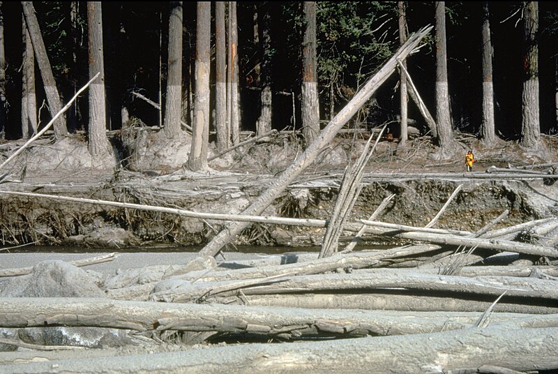
English: (copied description from USGS site): Nearly 135 miles (220 kilometers) of river channels surrounding the volcano [Mt. St. Helens] were affected by the lahars of May 18, 1980. A mudline left behind on trees shows depths reached by the mud. A scientist (middle right) gives scale. This view is along the Muddy River, southeast of Mount St. Helens. |
| Dată | Taken on 23 octombrie 1980 |
| Sursă | http://vulcan.wr.usgs.gov/Glossary/Lahars/description_lahars.html |
| Autor | Lyn Topinka, USGS |
Licențiere
This image is in the public domain in the United States because it only contains materials that originally came from the United States Geological Survey, an agency of the United States Department of the Interior. For more information, see the official USGS copyright policy.
|
Istoricul fișierului
Apăsați pe Data și ora pentru a vedea versiunea trimisă atunci.
| Data și ora | Miniatură | Dimensiuni | Utilizator | Comentariu | |
|---|---|---|---|---|---|
| actuală | 12 decembrie 2022 06:35 | | 2.904x1.947 (2,64 MB) | Hike395 | less jpeg compression, re-crop from original |
| 10 octombrie 2011 05:32 |  | 2.916x1.948 (1,21 MB) | Materialscientist | crop frame | |
| 2 septembrie 2010 18:02 |  | 3.072x2.048 (4,07 MB) | Awickert | {{Information |Description={{en|1=(copied description from USGS site): Nearly 135 miles (220 kilometers) of river channels surrounding the volcano [Mt. St. Helens] were affected by the lahars of May 18, 1980. A mudline left behind on trees shows depths re |
Utilizarea fișierului
Următoarele pagini conțin această imagine:
Utilizarea globală a fișierului
Următoarele alte proiecte wiki folosesc acest fișier:
- Utilizare la bg.wikipedia.org
- Utilizare la bn.wikipedia.org
- Utilizare la cs.wikipedia.org
- Utilizare la de.wikipedia.org
- Utilizare la en.wikipedia.org
- Utilizare la es.wikipedia.org
- Utilizare la fr.wikipedia.org
- Utilizare la he.wikipedia.org
- Utilizare la id.wikipedia.org
- Utilizare la it.wikipedia.org
- Utilizare la nl.wikipedia.org
- Utilizare la oc.wikipedia.org
- Utilizare la sk.wikipedia.org
- Utilizare la sv.wikipedia.org
- Utilizare la tr.wikipedia.org
- Utilizare la uk.wikipedia.org
- Utilizare la vi.wikipedia.org
- Utilizare la www.wikidata.org
- Utilizare la zh.wikipedia.org