Fișier:Mars Map.JPG

Conținutul paginii nu este suportat în alte limbi.
De la Wikipedia, enciclopedia liberă

Mărește rezoluția imaginii(2.180 × 1.244 pixeli, mărime fișier: 2,33 MB, tip MIME: image/jpeg)

Acest fișier se află la Wikimedia Commons. Consultați pagina sa descriptivă acolo.

Descriere fișier

Descriere
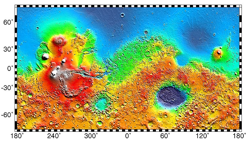
English: PIA02031: Maps of Mars Global Topography - Maps of Mars' global topography. The projections are Mercator to 70° latitude and stereographic at the poles with the south pole at left and north pole at right. Note the elevation difference between the northern and southern hemispheres. The Tharsis volcano-tectonic province is centered near the equator in the longitude range 220° E to 300° E and contains the vast east-west trending Valles Marineris canyon system and several major volcanic shields including Olympus Mons (18° N, 225° E), Alba Patera (42° N, 252° E), Ascraeus Mons (12° N, 248° E), Pavonis Mons (0°, 247° E), and Arsia Mons (9° S, 239° E). Regions and structures discussed in the text include Solis Planum (25° S, 270° E), Lunae Planum (10° N, 290° E), and Claritas Fossae (30° S, 255° E). Major impact basins include Hellas (45° S, 70° E), Argyre (50° S, 320° E), Isidis (12° N, 88° E), and Utopia (45° N, 110° E). This analysis uses an areocentric coordinate convention with east longitude positive.

Color coding on this map of the planet Mars indicates relative elevations based on data from the Mars Orbiter Laser Altimeter on NASA's Mars Global Surveyor. Red is higher elevation (up to +8 km and higher); yellow is 0 km; blue is lower elevation (down to -8 km). In longitude, the map extends from 70 degrees (north) to minus 70 degrees (south). The east-west axis is labeled at the bottom in degrees of east longitude, with the zero meridian at the center.

Data was produced by the Mars Global Surveyor's MOLA instrument

  • Producer ID: P50409 MRPS95009
Português: Mapa de Marte.
Русский: Карта Марса.
Dată (released)
Sursă http://photojournal.jpl.nasa.gov/catalog/PIA02031 (image link)
Autor NASA/JPL/GSFC
Permisiune
(Reutilizarea acestui fișier)
https://www.jpl.nasa.gov/imagepolicy/
Alte versiuni

Related Templates:

Related Images:

This image or video was catalogued by Jet Propulsion Laboratory of the United States National Aeronautics and Space Administration (NASA) under Photo ID: PIA02031.

This tag does not indicate the copyright status of the attached work. A normal copyright tag is still required. See Commons:Licensing.
Other languages:

Licențiere

Public domain Acest fişier este în domeniul public fiindcă a fost creat de NASA. Politica drepturilor de autor a NASA spune că „Materialul NASA nu este protejat de dreptul de autor atâta timp cât nu se precizează altfel”. (NASA copyright policy page sau JPL Image Use Policy).
Atenţie:
  • Folosirea logo-urilor NASA, insignelor şi emblemelor adiacente, este restricţionată conform legii Statelor Unite ale Americii 14 CFR 1221.
  • Site-ul NASA deţine un număr mare de poze din Programul spaţial sovietic şi alte agenţii spaţiale non-americane. Acestea pot să nu aparţină domeniului public.
  • Materialele luate de Telescopul spaţial Hubble pot avea drepturi de autor diferite dacă nu vin explicit de la Institutul Ştiinţific al Telescopului Spaţial (STScl). Detalii.
  • Toate materialele create de sonda SOHO se află sub incidenţa drepturilor de autor şi necesită permisiune pentru folosirea comercială non-educaţională. Detalii.
  • Imaginile ce au fost publicate pe site-ul Astronomy Picture of the Day (APOD) pot fi restricţionate de drepturile de autor. Detalii.

Jurnalul original al încărcărilor

Pagina originală de descriere a fost aici. Toate numele de utilizator de mai jos sunt pentru en.wikipedia.
  • 2012-10-26 05:43 Kelvin Case 613×350× (142399 bytes) {{Information |Description= {{en|Map of mars.}} {{pt|Mapa de Marte.}} http://photojournal.jpl.nasa.gov/catalog/PIA02031 PIA02031: Maps of Mars Global Topography Target Name:Mars Is a satellite of:Sol (our sun) Mission: Mars Global Surveyor (MGS) ...

Captions

Add a one-line explanation of what this file represents

Items portrayed in this file

subiectul reprezentat

27 mai 1999

Istoricul fișierului

Apăsați pe Data și ora pentru a vedea versiunea trimisă atunci.

Data și oraMiniaturăDimensiuniUtilizatorComentariu
actuală4 mai 2019 05:57Miniatură pentru versiunea din 4 mai 2019 05:572.180x1.244 (2,33 MB)HuntsterFull resolution from NASA/JPL.
6 mai 2014 12:23Miniatură pentru versiunea din 6 mai 2014 12:23613x350 (139 KB)Wikiuser13Transferred from en.wikipedia

Următoarele pagini conțin această imagine:

Utilizarea globală a fișierului

Informații