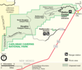
Fișier:Map of Carlsbad Caverns National Park.png

Mărimea acestei previzualizări: 705 × 600 pixeli. Alte rezoluții: 282 × 240 pixeli | 564 × 480 pixeli | 903 × 768 pixeli | 1.204 × 1.024 pixeli | 2.408 × 2.048 pixeli | 3.121 × 2.655 pixeli.
Mărește rezoluția imaginii (3.121 × 2.655 pixeli, mărime fișier: 704 KB, tip MIME: image/png)
Istoricul fișierului
Apăsați pe Data și ora pentru a vedea versiunea trimisă atunci.
| Data și ora | Miniatură | Dimensiuni | Utilizator | Comentariu | |
|---|---|---|---|---|---|
| actuală | 26 iunie 2022 03:10 |  | 3.121x2.655 (704 KB) | Joliv | Update to current NPS version (different spellings, better rasterization, removed ranger stn) |
| 23 martie 2008 13:40 |  | 1.104x936 (113 KB) | Finavon | border cropped | |
| 25 august 2006 09:00 |  | 1.145x945 (140 KB) | Huebi~commonswiki | {{Information |Description=Map of Carlsbad Caverns National Park |Source=http://www.nps.gov |Date= |Author= |Permission= |other_versions= }} {{PD-USGov-NPS}} category:Carlsbad Caverns National Park |
Utilizarea fișierului
Următoarele pagini conțin această imagine:
Utilizarea globală a fișierului
Următoarele alte proiecte wiki folosesc acest fișier:
- Utilizare la ca.wikipedia.org
- Utilizare la da.wikipedia.org
- Utilizare la de.wikipedia.org
- Utilizare la en.wikipedia.org
- Utilizare la fa.wikipedia.org
- Utilizare la fr.wikipedia.org
- Utilizare la hr.wikipedia.org
- Utilizare la ko.wikipedia.org
- Utilizare la nl.wikipedia.org
- Utilizare la pl.wikipedia.org
- Utilizare la tr.wikipedia.org

