
Fișier:Map Kingdom of Westphalia.jpg
Rezoluții mai mari nu sunt disponibile.
Map_Kingdom_of_Westphalia.jpg (348 × 409 pixeli, mărime fișier: 68 KB, tip MIME: image/jpeg)
| Acest fișier se află la Wikimedia Commons. Consultați pagina sa descriptivă acolo. |
Descriere fișier
| Descriere |
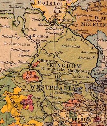
Nederlands: Koninkrijk Westfalen |
||||||||||||||||||||||
| Dată | |||||||||||||||||||||||
| Sursă | From The Historical Atlas by William R. Shepherd, 1926. | ||||||||||||||||||||||
| Autor |
|
||||||||||||||||||||||
| Permisiune (Reutilizarea acestui fișier) |
PCL states map is PD | ||||||||||||||||||||||
Licențiere
Autorul a murit în 1934, astfel încât această lucrare este, de asemenea, în domeniul public în ţările şi zonele în care durata drepturilor de autor este viaţa autorului plus 80 de ani sau mai puţin. | |
| Acest fișier a fost identificat ca fiind liber de orice restricții cunoscute privind legea drepturilor de autor, inclusiv toate drepturile conexe sau înrudite. | |
This work is in the public domain because it was published in the United States between 1929 and 1963, and although there may or may not have been a copyright notice, the copyright was not renewed. For further explanation, see Commons:Hirtle chart and the copyright renewal logs. Note that it may still be copyrighted in jurisdictions that do not apply the rule of the shorter term for US works (depending on the date of the author's death), such as Canada (70 years p.m.a.), Mainland China (50 years p.m.a., not Hong Kong or Macao), Germany (70 years p.m.a.), Mexico (100 years p.m.a.), Switzerland (70 years p.m.a.), and other countries with individual treaties.
|
 |
Jurnalul original al încărcărilor
- Originally from nl.wikipedia; description page is/was here.
(All user names refer to nl.wikipedia)
- 2004-08-16 09:49 Känsterle 348×409×8 (69732 bytes) Koninkrijk Westfalen - vrij te gebruiken voor educatieve doeleinden - http://www.lib.utexas.edu/maps/historical/
Map of the principality (later free state) of Lippe 1815–1945. From German Wikipedia and according to information there "Gemeinfrei" = public domain. {{PD-user|Störfix}}
Istoricul fișierului
Apăsați pe Data și ora pentru a vedea versiunea trimisă atunci.
| Data și ora | Miniatură | Dimensiuni | Utilizator | Comentariu | |
|---|---|---|---|---|---|
| actuală | 4 martie 2007 12:38 | | 348x409 (68 KB) | SieBot | {{Information |Description=Koninkrijk Westfalen {{PD-PCL|central_europe_1812.jpg|historical/shepherd/}} |Source=Originally from [http://nl.wikipedia.org nl.wikipedia]; description page is/was [http://nl.wikipedia.org/w/index.php?title=Image%3AKWestfale |
Utilizarea fișierului
Următoarele pagini conțin această imagine:
Utilizarea globală a fișierului
Următoarele alte proiecte wiki folosesc acest fișier:
- Utilizare la ca.wikipedia.org
- Utilizare la el.wikipedia.org
- Utilizare la eo.wikipedia.org
- Utilizare la et.wikipedia.org
- Utilizare la fa.wikipedia.org
- Utilizare la he.wikipedia.org
- Utilizare la id.wikipedia.org
- Utilizare la it.wikipedia.org
- Utilizare la sr.wikipedia.org
- Utilizare la zh.wikipedia.org