
Fișier:LocationBritishVirginIslands.svg

Mărimea acestei previzualizări PNG a acestui fișier SVG: 800 × 320 pixeli. Alte rezoluții: 320 × 128 pixeli | 640 × 256 pixeli | 1.024 × 410 pixeli | 1.280 × 512 pixeli | 2.560 × 1.024 pixeli | 1.750 × 700 pixeli.
Mărește rezoluția imaginii (Fișier SVG, cu dimensiunea nominală de 1.750 × 700 pixeli, mărime fișier: 324 KB)
| Acest fișier se află la Wikimedia Commons. Consultați pagina sa descriptivă acolo. |

|
A raster version of this image is available. It should be used in place of this vector image when superior.
File:LocationBritishVirginIslands.svg → File:LocationBritishVirginIslands.png
In general, it is better to use a good SVG version. |
Descriere fișier
| Descriere |
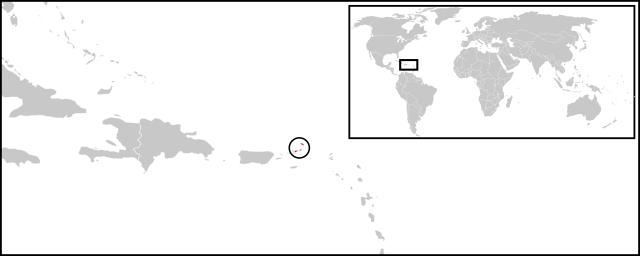
English: Location map for British Virgin Islands. Vectorised version of Image:LocationBritishVirginIslands.png |
| Dată | (UTC) |
| Sursă |
Această imagine vectorială a fost creată cu Inkscape . |
| Autor |
|
Licențiere
| Această imagine a fost retușată, ceea ce înseamnă că a fost modificată pe cale digitală și este diferită de cea inițială. Modificări: Combined two maps to form a newly vectorised version of the British Virgin Islands map. Imaginea inițială poate fi consultată aici: BlankMap-Caribbean.svg. Modificările au fost efectuate de către Visionholder.
|
| Eu, deținătorul drepturilor de autor ale acestei opere, o eliberez domeniului public. Aceasta se aplică în întreaga lume. În anumite țări există posibilitatea ca acest lucru să nu fie legal posibil; în acest caz: permit oricui să utilizeze această operă în orice scop, fără nicio condiție, atâta timp cât asemenea condiții nu sunt cerute de lege. |
Jurnalul original al încărcărilor
This image is a derivative work of the following images:
- File:BlankMap-World-v2.svg licensed with PD-self
- 2011-03-27T23:08:42Z Wayiran 1243x564 (209452 Bytes) Some correction on North-west border of Iran's map + south of Caspian sea
- 2008-12-03T18:02:36Z Harbin 1326x601 (192122 Bytes)
- 2008-12-02T19:55:14Z Harbin 1326x601 (197882 Bytes)
- 2008-12-02T19:04:59Z Harbin 1326x601 (176022 Bytes) {{Information |Description={{en|1=A blank map of the world as of 2005, with country outlines. Sovereign microstates less than 2 500 km² in area are depicted as circles (see Wikipedia:Image_talk:BlankMap-World-v2.png for list
- File:BlankMap-Caribbean.svg licensed with PD-self
- 2010-09-20T02:01:50Z NuclearVacuum 896x633 (274735 Bytes) new version
- 2010-02-23T15:29:09Z NuclearVacuum 2201x1507 (214283 Bytes) cleanup
- 2010-02-11T19:26:10Z NuclearVacuum 2201x1507 (211807 Bytes) I have started from scratch and made a completely new map of the Caribbean. This current version has an invalid code, but I will work on that later.
- 2009-09-22T00:08:34Z NuclearVacuum 940x477 (252618 Bytes) {{Information |Description={{en|1=Map of the [[:en:Caribbean|Caribbean nations]].}} |Source=[[:File:BlankMap-World6.svg]]{{Inkscape}} |Author=[[User:NuclearVacuum|NuclearVacuum]] |Date=2009-09-21 |Permission= |other_versions=
Uploaded with derivativeFX
Istoricul fișierului
Apăsați pe Data și ora pentru a vedea versiunea trimisă atunci.
| Data și ora | Miniatură | Dimensiuni | Utilizator | Comentariu | |
|---|---|---|---|---|---|
| actuală | 30 iunie 2011 05:08 | 1.750x700 (324 KB) | Maky | {{Bitmap version available|LocationBritishVirginIslands.png}} {{Information |Description={{en|1=Location map for British Virgin Islands.<br> Vectorised version of Image:LocationBritishVirginIslands.png}} |Source=*File:BlankMap-World-v2.svg |
Utilizarea fișierului
Următoarele pagini conțin această imagine:
Utilizarea globală a fișierului
Următoarele alte proiecte wiki folosesc acest fișier:
- Utilizare la ceb.wikipedia.org
- Utilizare la el.wikipedia.org
- Utilizare la en.wikipedia.org
- Utilizare la es.wikinews.org
- Utilizare la eu.wikipedia.org
- Utilizare la fr.wikipedia.org
- Utilizare la fr.wiktionary.org
- Utilizare la gcr.wikipedia.org
- Utilizare la ko.wikipedia.org
- Utilizare la mk.wikipedia.org
- Utilizare la pnb.wikipedia.org
- Utilizare la su.wikipedia.org
- Utilizare la sv.wikipedia.org
- Utilizare la vi.wikipedia.org
- Utilizare la www.wikidata.org