
Fișier:Cerescompositionmap.jpg

Mărimea acestei previzualizări: 800 × 400 pixeli. Alte rezoluții: 320 × 160 pixeli | 640 × 320 pixeli | 1.000 × 500 pixeli.
Mărește rezoluția imaginii (1.000 × 500 pixeli, mărime fișier: 246 KB, tip MIME: image/jpeg)
| Acest fișier se află la Wikimedia Commons. Consultați pagina sa descriptivă acolo. |
Descriere fișier
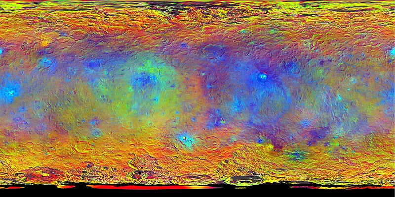
Complete map of the dwarf planet Ceres in false colour. Derived from the first mapping cycle at an altitude of 1,470 km (915 mi). Employs a combination of violet (440 nm) near-infrared (750 nm), and infrared (920 nm) filters.
Source: NASA / JPL-Caltech / UCLA / MPS / DLR / IDA
Licențiere
| Acest fişier este în domeniul public fiindcă a fost creat de NASA. Politica drepturilor de autor a NASA spune că „Materialul NASA nu este protejat de dreptul de autor atâta timp cât nu se precizează altfel”. (NASA copyright policy page sau JPL Image Use Policy). | ||
 |
Atenţie:
|
This work is in the public domain in the United States because it is a work prepared by an officer or employee of the United States Government as part of that person’s official duties under the terms of Title 17, Chapter 1, Section 105 of the US Code.
Note: This only applies to original works of the Federal Government and not to the work of any individual U.S. state, territory, commonwealth, county, municipality, or any other subdivision. This template also does not apply to postage stamp designs published by the United States Postal Service since 1978. (See § 313.6(C)(1) of Compendium of U.S. Copyright Office Practices). It also does not apply to certain US coins; see The US Mint Terms of Use.
|
 | |
| Acest fișier a fost identificat ca fiind liber de orice restricții cunoscute privind legea drepturilor de autor, inclusiv toate drepturile conexe sau înrudite. | ||
Istoricul fișierului
Apăsați pe Data și ora pentru a vedea versiunea trimisă atunci.
| Data și ora | Miniatură | Dimensiuni | Utilizator | Comentariu | |
|---|---|---|---|---|---|
| actuală | 21 august 2021 04:37 | | 1.000x500 (246 KB) | Serendipodous | Complete map of the dwarf planet Ceres in false colour. Derived from the first mapping cycle at an altitude of 1,470 km (915 mi). Employs a combination of violet (440 nm) near-infrared (750 nm), and infrared (920 nm) filters. NASA / JPL-Caltech / UCLA / MPS / DLR / IDA =={{int:license-header}}== {{PD-USGov-NASA}} Category:Maps of Ceres Category:Photos of Ceres by Dawn |
Utilizarea fișierului
Nicio pagină nu se leagă la această imagine.