
Fișier:Camargue map.png
Rezoluții mai mari nu sunt disponibile.
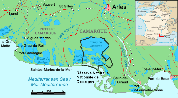
Camargue_map.png (718 × 396 pixeli, mărime fișier: 42 KB, tip MIME: image/png)
| Acest fișier se află la Wikimedia Commons. Consultați pagina sa descriptivă acolo. |
Descriere fișier
| Descriere | ||||
| Dată | ||||
| Sursă | Combination of CIA World Factbook map (Image:Fr-map.png) and Demis Map Server (http://www2.demis.nl/mapserver/mapper.asp) data with additional annotations and modifications by self. | |||
| Autor | ChrisO | |||
| Alte versiuni |
File:Camargue, Petite Caramgue et Parc naturel reg.png (relaunched and actualized)
|

Istoricul fișierului
Apăsați pe Data și ora pentru a vedea versiunea trimisă atunci.
| Data și ora | Miniatură | Dimensiuni | Utilizator | Comentariu | |
|---|---|---|---|---|---|
| actuală | 30 aprilie 2016 00:34 | | 718x396 (42 KB) | Rsuessbr | Writing of Petite-Camargue corrected |
| 10 august 2015 20:15 |  | 718x396 (42 KB) | Rsuessrb | Added: limits of the natural park (according to a map published by snpn (Société Nationale de Protection de la Nature), 2015 | |
| 20 martie 2012 04:23 |  | 718x396 (38 KB) | Ras67 | cropped | |
| 16 august 2006 23:52 |  | 720x398 (41 KB) | ChrisO | Map of the Camargue region, southern France By ~~~, derived from open source mapping | |
| 16 august 2006 23:46 |  | 720x398 (40 KB) | ChrisO | Map of the Camargue region, southern France By ~~~, derived from open source mapping |
Utilizarea fișierului
Următoarele pagini conțin această imagine:
Utilizarea globală a fișierului
Următoarele alte proiecte wiki folosesc acest fișier:
- Utilizare la af.wikipedia.org
- Utilizare la ar.wikipedia.org
- Utilizare la az.wikipedia.org
- Utilizare la br.wikipedia.org
- Utilizare la co.wikipedia.org
- Utilizare la cs.wikipedia.org
- Utilizare la cy.wikipedia.org
- Utilizare la de.wikipedia.org
- Utilizare la en.wikipedia.org
- Utilizare la eo.wikipedia.org
- Utilizare la es.wikipedia.org
- Utilizare la fi.wikipedia.org
- Utilizare la fr.wikipedia.org
- Utilizare la gl.wikipedia.org
- Utilizare la hu.wikipedia.org
- Utilizare la id.wikipedia.org
- Utilizare la it.wikipedia.org
- Utilizare la ja.wikipedia.org
- Utilizare la ko.wikipedia.org
- Utilizare la lt.wikipedia.org
- Utilizare la mt.wikipedia.org
- Utilizare la nl.wikipedia.org
- Utilizare la nn.wikipedia.org
- Utilizare la no.wikipedia.org
- Utilizare la oc.wikipedia.org
Vizualizați utilizările globale ale acestui fișier.