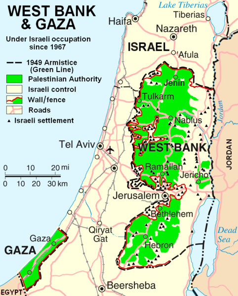
Fișier:West Bank & Gaza Map 2007 (Settlements).png

Mărimea acestei previzualizări: 482 × 599 pixeli. Alte rezoluții: 193 × 240 pixeli | 386 × 480 pixeli | 780 × 970 pixeli.
Mărește rezoluția imaginii (780 × 970 pixeli, mărime fișier: 86 KB, tip MIME: image/png)
Istoricul fișierului
Apăsați pe Data și ora pentru a vedea versiunea trimisă atunci.
| Data și ora | Miniatură | Dimensiuni | Utilizator | Comentariu | |
|---|---|---|---|---|---|
| actuală | 30 octombrie 2013 01:55 |  | 780x970 (86 KB) | Scott | Correct capitalization in legend. |
| 30 octombrie 2013 01:54 |  | 780x970 (86 KB) | Scott | Correct capitalization in legend. | |
| 12 ianuarie 2009 09:21 |  | 780x970 (105 KB) | HowardMorland | Replace .gif file with identical .png file <!--{{ImageUpload|basic}}--> |
Utilizarea fișierului
Următoarele pagini conțin această imagine:
Utilizarea globală a fișierului
Următoarele alte proiecte wiki folosesc acest fișier:
- Utilizare la am.wikipedia.org
- Utilizare la ar.wikipedia.org
- Utilizare la ast.wikipedia.org
- Utilizare la azb.wikipedia.org
- Utilizare la bg.wikipedia.org
- Utilizare la ca.wikipedia.org
- Utilizare la ckb.wikipedia.org
- Utilizare la cs.wikipedia.org
- Utilizare la cy.wikipedia.org
- Utilizare la da.wikipedia.org
- Utilizare la de.wikipedia.org
- Utilizare la de.wikinews.org
- Utilizare la de.wikivoyage.org
- Utilizare la en.wikipedia.org
- Talk:List of ongoing armed conflicts
- User:Timeshifter/Userboxes
- User:Gimmetrow/test
- User:Gimmetrow/test2
- User:Keizers
- Talk:Jerusalem/Archive 15
- Talk:Palestinian National Authority/Archive 2
- Wikipedia:Top 25 Report/July 13 to 19, 2014
- Wikipedia:Top 25 Report/July 20 to 26, 2014
- Wikipedia:Top 25 Report/July 27 to August 2, 2014
- Talk:State of Palestine/Archive 12
- User:Timeshifter/Userboxes/Palestine: Peace Not Apartheid. By Jimmy Carter
- User:Dare2Leap/info
- User:Timeshifter/Archive 2
- Wikipedia talk:WikiProject Israel Palestine Collaboration/Archive 9
- Utilizare la en.wikinews.org
- Utilizare la eo.wikipedia.org
- Utilizare la es.wikipedia.org
- Utilizare la eu.wikipedia.org
- Utilizare la fa.wikipedia.org
- Utilizare la fi.wikipedia.org
- Utilizare la fo.wikipedia.org
- Utilizare la fr.wikipedia.org
Vizualizați utilizările globale ale acestui fișier.
