Fișier:Satelite image of Malta.jpg
Conținutul paginii nu este suportat în alte limbi.
De la Wikipedia, enciclopedia liberă

Mărește rezoluția imaginii(2.760 × 2.124 pixeli, mărime fișier: 723 KB, tip MIME: image/jpeg)

Acest fișier se află la Wikimedia Commons. Consultați pagina sa descriptivă acolo.

Descriere fișier

Descriere
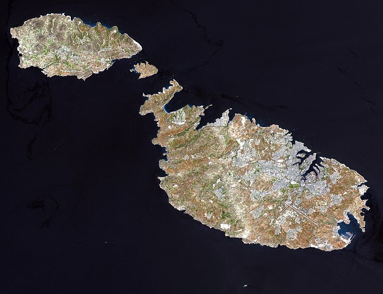
English: Malta, an independent republic, consists of a small group of islands—Malta, Gozo, Kemmuna, Kemmunett, and Filfla—located in the Mediterranean Sea south of Sicily, with a total area of 316 square kilometers. The capital and leading port of the country is Valletta, which appears as a gray patch around the two deep inlets on Malta’s northern coastline. About 400,000 people live on this island nation. The islands of Malta consist of low-lying coralline limestone plateaus surrounded by impermeable clay slopes. The highest point is 239 meters above sea level.

The many ancient monuments and remains on Malta attest to the great age of its civilization. Remains from Stone Age and Bronze Age peoples have been found in subterranean burial chambers. The islands became a Phoenician colony about 1000 B.C. They were later occupied by the Greeks, who called the colony Melita, and later the islands passed successively into the possession of Carthage and Rome. The islands were occupied by Arabs in 870 A.D. A Norman army conquered the Maltese Arabs in 1090, and Malta was later made a feudal fief of the kingdom of Sicily. In 1530 Holy Roman Emperor Charles V granted Malta to the Knights of Saint John of Jerusalem, who ruled the islands until the 19th century. In 1798 Napoleon invaded and occupied the islands during his Egyptian campaign. Unwilling to be ruled by France, the Maltese appealed to Britain, and in 1799 British naval officer Horatio Nelson besieged Valletta and compelled the withdrawal of the French. In 1814 Malta became part of the British Empire as a crown colony.

This natural-color image was acquired on July 29, 2001, by the Advanced Spaceborne Thermal Emission and Reflection Radiometer (ASTER) aboard NASA’s Terra satellite.

Image courtesy NASA/GSFC/MITI/ERSDAC/JAROS, and U.S./Japan ASTER Science Team
Sursă

http://earthobservatory.nasa.gov/Newsroom/NewImages/images.php3?img_id=16706 NASA]


Public domain Acest fişier este în domeniul public fiindcă a fost creat de NASA. Politica drepturilor de autor a NASA spune că „Materialul NASA nu este protejat de dreptul de autor atâta timp cât nu se precizează altfel”. (NASA copyright policy page sau JPL Image Use Policy).
Atenţie:
  • Folosirea logo-urilor NASA, insignelor şi emblemelor adiacente, este restricţionată conform legii Statelor Unite ale Americii 14 CFR 1221.
  • Site-ul NASA deţine un număr mare de poze din Programul spaţial sovietic şi alte agenţii spaţiale non-americane. Acestea pot să nu aparţină domeniului public.
  • Materialele luate de Telescopul spaţial Hubble pot avea drepturi de autor diferite dacă nu vin explicit de la Institutul Ştiinţific al Telescopului Spaţial (STScl). Detalii.
  • Toate materialele create de sonda SOHO se află sub incidenţa drepturilor de autor şi necesită permisiune pentru folosirea comercială non-educaţională. Detalii.
  • Imaginile ce au fost publicate pe site-ul Astronomy Picture of the Day (APOD) pot fi restricţionate de drepturile de autor. Detalii.
Autor

derivative works

Creații derivate din acest fișier:  Archipel maltais.jpg

Istoricul fișierului

Apăsați pe Data și ora pentru a vedea versiunea trimisă atunci.

Data și oraMiniaturăDimensiuniUtilizatorComentariu
actuală24 decembrie 2004 07:05Miniatură pentru versiunea din 24 decembrie 2004 07:052.760x2.124 (723 KB)Chris 73

Următoarele pagini conțin această imagine:

Utilizarea globală a fișierului

Următoarele alte proiecte wiki folosesc acest fișier:

Vizualizați utilizările globale ale acestui fișier.