Fișier:Ocean drainage.png
Conținutul paginii nu este suportat în alte limbi.
De la Wikipedia, enciclopedia liberă

Mărește rezoluția imaginii(1.256 × 656 pixeli, mărime fișier: 75 KB, tip MIME: image/png)

Acest fișier se află la Wikimedia Commons. Consultați pagina sa descriptivă acolo.

Descriere fișier

Imaginile din această galerie trebuie recreat(ă/e) sub format vectorial ca fișier SVG. Acest format are mai multe avantaje; vezi Commons:Media for cleanup pentru mai multe informații. Dacă deja este disponibilă o versiune SVG a acestei imagini, vă rugăm să o încărcați. După încărcarea pe serverele Commons a versiunii SVG, înlocuiți acest format cu formatul {{vector version available|noul nume al imaginii.svg}}.
Descriere
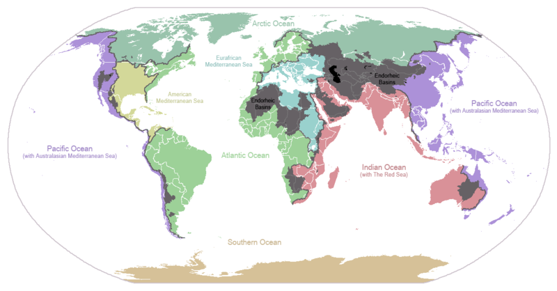
English: I made this map and hereby release it into the public domain. It shows the drainage basins for the major oceans and seas; grey areas are endorheic basins that do not drain to the ocean. Data is from the USGS Hydro1k project; information for Saskatchewan corrected by information from the Commission for Environmental Cooperation -- Citynoise
Description in large font size is used for oceans, in smaller font size is used for mediterranean seas. Only these mediterranean seas are listed which correspond to the definition of german Geographer Ernst Neef: A mediterranean sea is a sea between two Continents. Also found here: de:Mittelmeer --W like wiki (talk) 00:55, 12 March 2011 (UTC)
Français : Carte du monde des bassins versants. Les zones de couleur anthracite représentent les bassins endoréiques, qui ne sont reliés à aucun océan.
Čeština: Úmoří světových oceánů, popř. významných moří či zálivů. Legenda úmoří: fialová - Tichý oceán, růžová - Indický oceán, zelená - Atlantický oceán, azurová - Severní ledový oceán, béžová - Jižní oceán, modrá - Mexický záliv, světle modrá - Středozemní moře, šedá - oblast neústící ve světovém oceánu
Dată 24 ianuarie 2007 (original upload date)
Sursă Transferred from en.wikipedia to Commons.
Autor Citynoise at engleză Wikipedia
Alte versiuni File:Major endorheic basins.png

Licențiere

Public domain Această operă a fost eliberată domeniului public de către autorul său, Citynoise at engleză Wikipedia. Aceasta se aplică în întreaga lume.
În anumite țări există posibilitatea ca acest lucru să nu fie legal posibil; în acest caz:
Citynoise permite oricui să utilizeze această operă în orice scop, fără nicio condiție, atâta timp cât asemenea condiții nu sunt cerute de lege.

Jurnalul original al încărcărilor

Pagina originală de descriere a fost aici. Toate numele de utilizator de mai jos sunt pentru en.wikipedia.
  • 2007-05-20 17:59 Bolonium 1256×656×8 (50194 bytes) I made this map and hereby release it into the public domain. It shows the drainage basins for the major oceans and seas; grey areas are endorheic basins that do not drain to the ocean. -- [[User:Citynoise|Citynoise]] == Licensing == {{self
  • 2007-01-24 07:21 Citynoise 1256×656×8 (63359 bytes) I made this map and hereby release it into the public domain. It shows the drainage basins for the major oceans and seas; grey areas are endorheic basins that do not drain to the ocean.
  • 2007-01-24 06:09 Citynoise 1256×656×8 (57358 bytes) I made this map and hereby release it into the public domain. It shows the drainage basins for the major oceans and seas; grey areas are endorheic basins that do not drain to the ocean.
  • 2007-01-24 05:10 Citynoise 1256×656×8 (56360 bytes) I made this map and hereby release it into the public domain. It shows the drainage basins for the major oceans and seas; grey areas are endorheic basins that do not drain to the ocean.
  • 2007-01-24 04:55 Citynoise 1256×656×8 (56373 bytes) I made this map and hereby release it into the public domain. It shows the drainage basins for the major oceans and seas; grey areas are endorheic basins that do not drain to the ocean.

Captions

Add a one-line explanation of what this file represents
Drainage basins of the world, colored by ocean outlet. Endorheic basins not draining to an ocean are colored dark gray. Continental divides are indicated by dark lines.

Items portrayed in this file

subiectul reprezentat

24 ianuarie 2007

Istoricul fișierului

Apăsați pe Data și ora pentru a vedea versiunea trimisă atunci.

Data și oraMiniaturăDimensiuniUtilizatorComentariu
actuală7 octombrie 2015 02:25Miniatură pentru versiunea din 7 octombrie 2015 02:251.256x656 (75 KB)AcidSnowFixed Somalia.
12 martie 2011 03:39Miniatură pentru versiunea din 12 martie 2011 03:391.256x656 (76 KB)W like wikiInsert Description. Big font size is used for oceans, smaller font size is used for mediterranean seas.
30 iunie 2009 14:13Miniatură pentru versiunea din 30 iunie 2009 14:131.256x656 (40 KB)U7vGuntransparentize background,improve some details.
26 iulie 2008 23:45Miniatură pentru versiunea din 26 iulie 2008 23:451.256x656 (62 KB)Citynoise{{Information |Description=added endorheic basins in Saskatchewan. |Source=my own work |Date=July 2008 |Author=Citynoise |Permission=all rights released |other_versions= }}
27 noiembrie 2007 22:46Miniatură pentru versiunea din 27 noiembrie 2007 22:461.256x656 (49 KB)File Upload Bot (Magnus Manske) {{BotMoveToCommons|en.wikipedia}} {{Information |Description={{en|I made this map and hereby release it into the public domain. It shows the drainage basins for the major oceans and seas; grey areas are en:endorheic basins that do not drain to the

Următoarele pagini conțin această imagine:

Utilizarea globală a fișierului

Următoarele alte proiecte wiki folosesc acest fișier:

Vizualizați utilizările globale ale acestui fișier.

Informații