
Fișier:Nansen Fram Map.png
Rezoluții mai mari nu sunt disponibile.
Nansen_Fram_Map.png (800 × 479 pixeli, mărime fișier: 195 KB, tip MIME: image/png)
| Acest fișier se află la Wikimedia Commons. Consultați pagina sa descriptivă acolo. |
Descriere fișier
| Descriere |
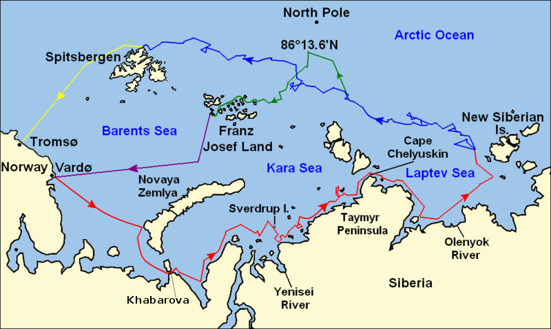
Map of the Arctic Ocean showing the routes taken during the 1893–96 Nansen's Fram expedition: Fram's route eastward from Vardø to the Siberian coast, turning north at the New Siberian Islands to enter the pack ice. July – September 1893 Fram's drift in the ice from the New Siberian Islands, north and west to Spitsbergen, September 1893 – August 1896 Nansen and Johansen's march to Farthest North, 86°20'N, and their subsequent retreat to Cape Flora in Franz Josef Land. February 1895 – June 1896 Nansen and Johansen's return to Vardø from Cape Flora, August 1896 Fram's voyage from Spitsbergen to Tromsø, August 1896 |
| Dată | |
| Sursă | Base map of European and Asian mainland is from File:Map of Russian Subjects old.png by User:fremantleboy, map of Spitsbergen (Svalbard) is based on File:Bjornoya map.png by User:NormanEinstein. Voyage traces based on this map from The Northern Lights Route. First published in Nansen, Fridtjof: Farthest North, Constable & Co, London 1897 |
| Autor | User:fremantleboy, User:NormanEinstein, Ruhrfisch |
| Permisiune (Reutilizarea acestui fișier) |
GFDL, CC-BY-SA |
| Alte versiuni |
|


|
O versiune vectorială a acestei imagini (SVG) este disponibilă.
Aceasta ar trebui folosită în locul vechii imagini pentru o afișare mai bună la rezoluții mari. File:Nansen Fram Map.png → File:Nansen Fram Map.svg
Pentru mai multe informații despre imaginile vectoriale, consultați pagina Commons transition to SVG. Vedeți, de asemenea, și informațiile despre modul în care software-ul MediaWiki acceptă imagini în format SVG. |
 |
Licențiere
Eu, deținătorul drepturilor de autor ale acestei opere, prin prezenta îmi public lucrarea sub următoarele licențe:

|
Se permite copierea, distribuirea și/sau modificarea acestui document conform termenilor Documentației de licență liberă GNU, versiunea 1.2 sau orice altă versiune ulterioară publicată de Free Software Foundation, fără părți neschimbabile, texte de pe copertele principale și finale. O copie a acestei licențe este inclusă în secțiunea numită Documentația de licență liberă GNU. |
This file is licensed under the Creative Commons Attribution-Share Alike 4.0 International, 3.0 Unported, 2.5 Generic, 2.0 Generic and 1.0 Generic license.
- Sunteți liber:
- să partajați cu alții – aveți dreptul de a copia, distribui și transmite opera
- să adaptați – aveți dreptul de a adapta opera
- În următoarele condiții:
- atribuind – Trebuie să atribuiți opera corespunzător, introducând o legătură către licență și indicând dacă ați făcut schimbări. Puteți face asta prin orice metodă rezonabilă, dar nu într-un fel care ar sugera faptul că persoana ce a licențiat conținutul v-ar susține sau ar aproba folosirea de către dumneavoastră a operei sale.
- partajând în condiții identice – Dacă modificați, transformați sau creați pe baza acestei opere, trebuie să distribuiți opera rezultată doar sub aceeași licență sau sub o licență similară acesteia.
Puteți alege licența pe care o doriți.
Istoricul fișierului
Apăsați pe Data și ora pentru a vedea versiunea trimisă atunci.
| Data și ora | Miniatură | Dimensiuni | Utilizator | Comentariu | |
|---|---|---|---|---|---|
| actuală | 8 mai 2011 15:16 | | 800x479 (195 KB) | Chris55 | Added [http://website.lineone.net/~polar.publishing/khabarova.htm Khabarova] where they picked up the dogs. |
| 21 octombrie 2009 18:50 |  | 1.003x601 (78 KB) | Ruhrfisch | Make arrowheads less triangular (indentations at rear) | |
| 21 octombrie 2009 18:23 |  | 1.003x601 (78 KB) | Ruhrfisch | Add arrowheads per FAC | |
| 20 octombrie 2009 21:50 |  | 1.003x601 (78 KB) | Ruhrfisch | Make magenta line purple | |
| 11 octombrie 2009 16:36 |  | 1.003x601 (78 KB) | Ruhrfisch | Yellow line for orange, some labels smaller, Farthest North replaced with actual figure, all other info the same | |
| 11 octombrie 2009 06:08 |  | 1.003x601 (80 KB) | Ruhrfisch | Darker green for that line, all other information is the same | |
| 11 octombrie 2009 05:46 |  | 1.003x601 (80 KB) | Ruhrfisch | Added last two lines for ice voyages, added last labels, all other information the same. | |
| 9 octombrie 2009 22:30 |  | 1.003x601 (73 KB) | Ruhrfisch | Add labels, two more voyage lines, all other information is the same | |
| 9 octombrie 2009 19:12 |  | 1.003x601 (57 KB) | Ruhrfisch | == Summary == {{Information |Description = Map of the Arctic Ocean showing the path of Nansen's Fram expedition 1893 to 1896 |Source = Base map of European mainland is from [[:File:Map of Russian Subjects old.png] |
Utilizarea fișierului
Nicio pagină nu se leagă la această imagine.
Utilizarea globală a fișierului
Următoarele alte proiecte wiki folosesc acest fișier:
- Utilizare la bg.wikipedia.org
- Utilizare la en.wikipedia.org
- Utilizare la es.wikipedia.org
- Utilizare la fr.wikipedia.org
- Utilizare la hr.wikipedia.org
- Utilizare la id.wikipedia.org
- Utilizare la ja.wikipedia.org
- Utilizare la pt.wikipedia.org
- Utilizare la sl.wikipedia.org