
Fișier:Kingdom of Arles 1000.svg

Mărimea acestei previzualizări PNG a acestui fișier SVG: 485 × 340 pixeli. Alte rezoluții: 320 × 224 pixeli | 640 × 449 pixeli | 1.024 × 718 pixeli | 1.280 × 897 pixeli | 2.560 × 1.795 pixeli.
Mărește rezoluția imaginii (Fișier SVG, cu dimensiunea nominală de 485 × 340 pixeli, mărime fișier: 1,25 MB)
| Acest fișier se află la Wikimedia Commons. Consultați pagina sa descriptivă acolo. |
Descriere fișier
Această imagine vectorială a fost creată cu Inkscape .


.svg)
.svg)
.svg)
.svg)
.svg)


.svg)
.svg)
.svg)


.png)
.png)


.svg)


.svg)

.svg)


.svg)
.svg)
.svg)
.svg)


.svg)
.png)


.svg)


.svg)
.svg)


.svg)


.svg)


.svg)
.svg)
.svg)
.svg)
.svg)
.svg)
.svg)
.svg)
_cropped.svg)
.svg)
.svg)
.svg)
.svg)
.svg)
.svg)
.svg)
.svg)
.svg)
.svg)
.svg)
.svg)
.svg)
.svg)
.svg)
.svg)
.svg)
.svg)
.svg)
.svg)
.svg)
.svg)
.svg)
.svg)
.svg)
.svg)
.svg)
.svg)
.svg)
.svg)
.svg)
.svg)
.svg)
.svg)
.svg)
.svg)
.svg)
.svg)
.svg)
.svg)
.svg)
.svg)
.svg)
.svg)
.svg)
Licențiere
Acest fișier a fost eliberat sub licența Creative Commons Atribuire și distribuire în condiții identice 4.0 Internațională.
- Sunteți liber:
- să partajați cu alții – aveți dreptul de a copia, distribui și transmite opera
- să adaptați – aveți dreptul de a adapta opera
- În următoarele condiții:
- atribuind – Trebuie să atribuiți opera corespunzător, introducând o legătură către licență și indicând dacă ați făcut schimbări. Puteți face asta prin orice metodă rezonabilă, dar nu într-un fel care ar sugera faptul că persoana ce a licențiat conținutul v-ar susține sau ar aproba folosirea de către dumneavoastră a operei sale.
- partajând în condiții identice – Dacă modificați, transformați sau creați pe baza acestei opere, trebuie să distribuiți opera rezultată doar sub aceeași licență sau sub o licență similară acesteia.
Istoricul fișierului
Apăsați pe Data și ora pentru a vedea versiunea trimisă atunci.
| Data și ora | Miniatură | Dimensiuni | Utilizator | Comentariu | |
|---|---|---|---|---|---|
| actuală | 23 mai 2016 17:41 | | 485x340 (1,25 MB) | Alphathon | Corrected status of Bohemia |
| 22 mai 2016 21:16 |  | 485x340 (1,24 MB) | Alphathon | Split Capua from Benevento and removed both from HRE, along with Spoleto | |
| 22 mai 2016 19:42 |  | 485x340 (1,23 MB) | Alphathon | Added Welsh kingdoms/principalities and removed Rügen from the HRE | |
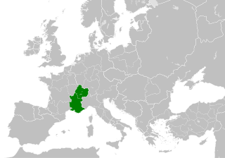
| 22 mai 2016 18:39 |  | 485x340 (1,23 MB) | Alphathon | == {{int:filedesc}} == {{Inkscape}} {{Information |Description={{en|A map of the Kingdom of Arles/Arelat/Burgundy within Europe circa 1000 CE. The main subdivisions of the Byzantine Empire, Holy Roman Empire, Burgundy, France a... |
Utilizarea fișierului
Următoarele pagini conțin această imagine:
Utilizarea globală a fișierului
Următoarele alte proiecte wiki folosesc acest fișier:
- Utilizare la ast.wikipedia.org
- Utilizare la az.wikipedia.org
- Utilizare la ca.wikipedia.org
- Utilizare la cs.wikipedia.org
- Utilizare la el.wikipedia.org
- Utilizare la en.wikipedia.org
- Utilizare la eo.wikipedia.org
- Utilizare la es.wikipedia.org
- Utilizare la fa.wikipedia.org
- Utilizare la fi.wikipedia.org
- Utilizare la fr.wikipedia.org
- Utilizare la he.wikipedia.org
- Utilizare la hu.wikipedia.org
- Utilizare la id.wikipedia.org
- Utilizare la it.wikipedia.org
- Utilizare la it.wikiquote.org
- Utilizare la ko.wikipedia.org
- Utilizare la lv.wikipedia.org
- Utilizare la mt.wikipedia.org
- Utilizare la pl.wikipedia.org
- Utilizare la sl.wikipedia.org
- Utilizare la th.wikipedia.org
- Utilizare la uk.wikipedia.org
- Utilizare la vi.wikipedia.org
- Utilizare la www.wikidata.org
- Utilizare la zh.wikipedia.org
.svg)