
Fișier:Anglo American War 1812 Locations map-en.svg

Mărește rezoluția imaginii (Fișier SVG, cu dimensiunea nominală de 1.052 × 744 pixeli, mărime fișier: 136 KB)
| Acest fișier se află la Wikimedia Commons. Consultați pagina sa descriptivă acolo. |
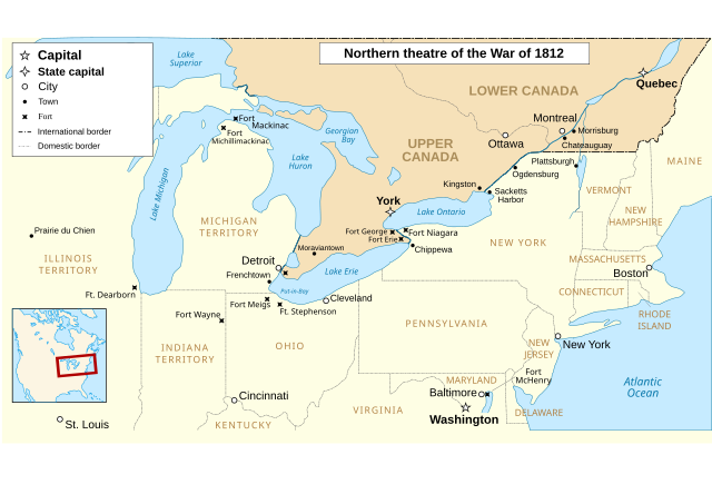
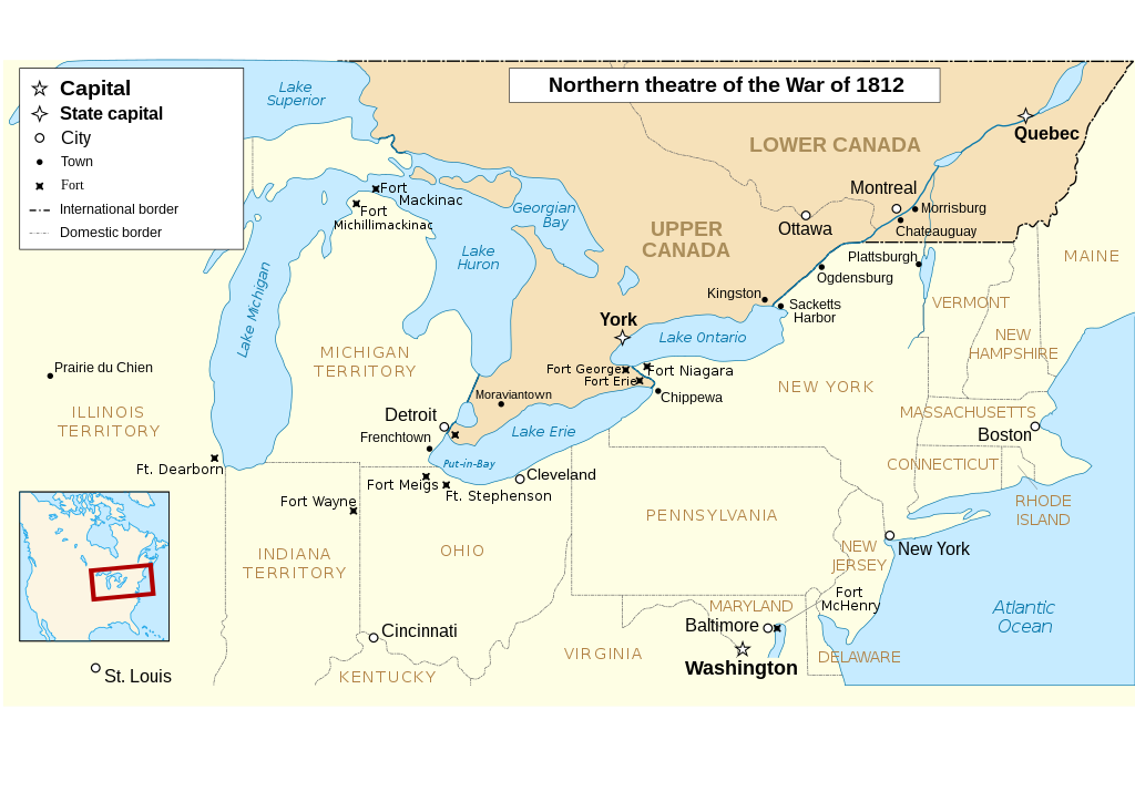
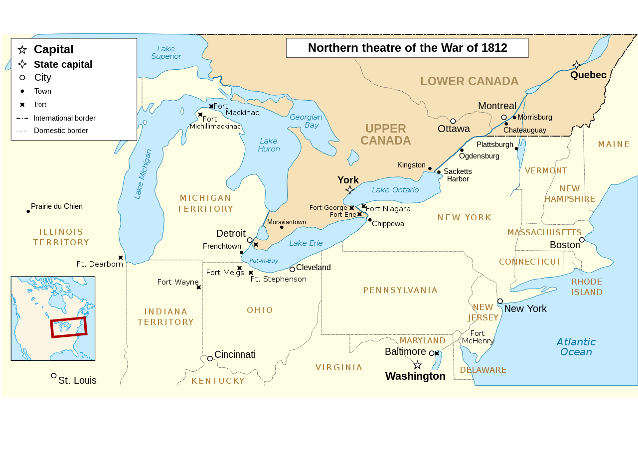
The map omits two of the most important battles of the war as far as the territorial outcome of the Treaty of Ghent. The Battle of Lake Erie (aka Battle of Put in Bay) was where the entire British Upper Great Lakes Fleet surrendered. With the Great Lakes supply lines cut, the British and their Indian allies destroyed the forts at Detroit and Amherstburg and tried to retreat up the Thames River hoping to reach the main British base at Burlington on Lake Ontario.The American army under General Harrison caught up with them at Moraviantown and the British were defeated. Most important was that Tecumseh was killed at this battle and, with his death, the Indian Confederation fell apart and thousands of the warriors just went home. When the Duke of Wellington, fresh from defeating Napoleon, was subsequently offered command of the British Army in America, he said he'd go but couldn't promise anything unless the Navy first got control of the Great Lakes. Otherwise, he told the negotiators that they may as well give up on any territorial demands and just make peace with the US. See "Three Strikes in the War of 1812".
| Descriere |
English: Main locations of the War of 1812 between the United States and the United Kingdom Français : Principaux théâtres d'opérations de la Guerre de 1812 entre les États-Unis et le Royaume-Uni. Español: Principales teatros de operaciones de la Guerra de 1812 entre los Estados Unidos y el Reino Unido. |
| Dată | (UTC) |
| Sursă | |
| Autor |
|
| Alte versiuni |
Creații derivate din acest fișier: |
| Această imagine a fost retușată, ceea ce înseamnă că a fost modificată pe cale digitală și este diferită de cea inițială. Modificări: translated to english. Imaginea inițială poate fi consultată aici: Anglo American War 1812 Locations map-fr.svg. Modificările au fost efectuate de către P. S. Burton.
|
- Sunteți liber:
- să partajați cu alții – aveți dreptul de a copia, distribui și transmite opera
- să adaptați – aveți dreptul de a adapta opera
- În următoarele condiții:
- atribuind – Trebuie să atribuiți opera corespunzător, introducând o legătură către licență și indicând dacă ați făcut schimbări. Puteți face asta prin orice metodă rezonabilă, dar nu într-un fel care ar sugera faptul că persoana ce a licențiat conținutul v-ar susține sau ar aproba folosirea de către dumneavoastră a operei sale.
- partajând în condiții identice – Dacă modificați, transformați sau creați pe baza acestei opere, trebuie să distribuiți opera rezultată doar sub aceeași licență sau sub o licență similară acesteia.

|
Se permite copierea, distribuirea și/sau modificarea acestui document conform termenilor Documentației de licență liberă GNU, versiunea 1.2 sau orice altă versiune ulterioară publicată de Free Software Foundation, fără părți neschimbabile, texte de pe copertele principale și finale. O copie a acestei licențe este inclusă în secțiunea numită Documentația de licență liberă GNU. |
Jurnalul original al încărcărilor
This image is a derivative work of the following images:
- File:Anglo_American_War_1812_Locations_map-fr.svg licensed with Cc-by-sa-3.0,2.5,2.0,1.0, GFDL
- 2008-06-20T23:26:18Z MaCRoEco 1494x830 (154198 Bytes) {{Information |Description= |Source= |Date= |Author= |Permission= |other_versions= }}
- 2008-06-17T16:04:43Z Sémhur 1494x830 (163461 Bytes) Mistake : Fort Henry => Fort McHenry
- 2008-06-17T09:50:41Z Sémhur 1494x830 (163245 Bytes) {{Information |Description={{en|1=Main locations of the [[:en:War of 1812|War of 1812]] between the United States and the United Kingdom}} {{fr|1=Principaux théâtres d'opérations de la [[:fr:Guerre de 1812|Guerre de 1812]]
Uploaded with derivativeFX
Istoricul fișierului
Apăsați pe Data și ora pentru a vedea versiunea trimisă atunci.
| Data și ora | Miniatură | Dimensiuni | Utilizator | Comentariu | |
|---|---|---|---|---|---|
| actuală | 6 martie 2023 03:52 | | 1.052x744 (136 KB) | Hunter9502 | Reverted to version as of 08:55, 7 February 2021 (UTC) - February 2023 version has broken SVG formatting |
| 4 februarie 2023 03:15 |  | 1.600x915 (493 KB) | Yourlocallordandsavior | Removed useless sections. | |
| 7 februarie 2021 11:55 |  | 1.052x744 (136 KB) | Kevin1776 | Added requested missing locations (Moraviantown, Put-in-Bay), moved Fort Meigs to correct locations, other font & readability adjustments. | |
| 25 iulie 2011 21:03 |  | 1.494x830 (128 KB) | Amirki | minor color change | |
| 23 ianuarie 2011 00:05 |  | 1.494x830 (153 KB) | P. S. Burton | {{Information |Description={{en|1=Main locations of the War of 1812 between the United States and the United Kingdom}} {{fr|1=Principaux théâtres d'opérations de la Guerre de 1812 entre les États-Unis et le R |
Utilizarea fișierului
Următoarele pagini conțin această imagine:
Utilizarea globală a fișierului
Următoarele alte proiecte wiki folosesc acest fișier:
- Utilizare la af.wikipedia.org
- Utilizare la de.wikipedia.org
- Utilizare la en.wikipedia.org
- Utilizare la gd.wikipedia.org
- Utilizare la he.wikipedia.org
- Utilizare la hr.wikipedia.org
- Utilizare la ru.wikipedia.org
- Utilizare la sv.wikipedia.org
- Utilizare la vi.wikipedia.org