
Fișier:10May 16May Battle of Belgium.PNG

Mărimea acestei previzualizări: 775 × 599 pixeli. Alte rezoluții: 311 × 240 pixeli | 621 × 480 pixeli | 891 × 689 pixeli.
Mărește rezoluția imaginii (891 × 689 pixeli, mărime fișier: 156 KB, tip MIME: image/png)
| Acest fișier se află la Wikimedia Commons. Consultați pagina sa descriptivă acolo. |
| Descriere |
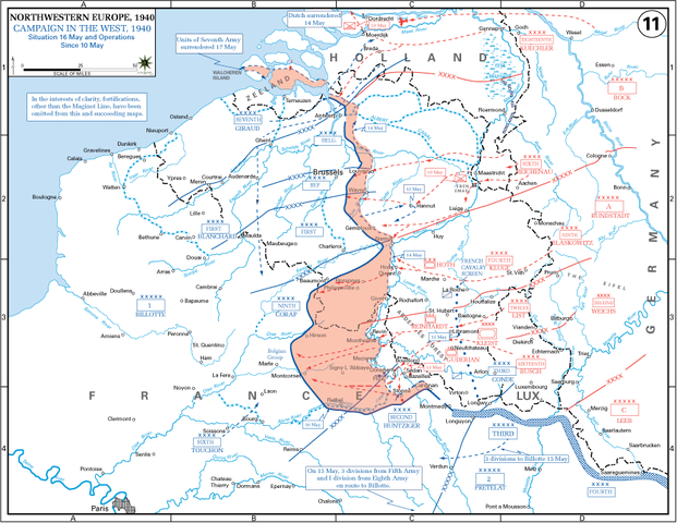
English: The German advance between 10 May and 16 May 1940. The red area denotes the territory captured by Germany during this time. The German field armies and Corps are shown in red. The red plan icon indicates the German airborne attack on the Belgian fortress of Eben-Emael. The operating area of the various Belgian, British, and French field armies and Army groups are shown in blue. The checkered white and blue area denotes the French Maginot Line. The commanders of the various units are shown under their respective formation. Solid lines represent the boundaries between each major unit. Dotted lines depict lines of advance. Key dates are shown in boxes. |
| Dată | (UTC) |
| Sursă |
(Original text: http://www.dean.usma.edu/history/web03/atlases/ww2%20europe/EuropeanTheaterGIF/WWIIEurope11.gif) Archive link to original website used for the map and the archive link to the map source page. Current link to map, and link to map source page. |
| Autor | The History Department of the United States Military Academy |
| Alte versiuni | File:10May-16May1940-Fall Gelb.jpg |
Licențiere
This file is a work of a U.S. Army soldier or employee, taken or made as part of that person's official duties. As a work of the U.S. federal government, it is in the public domain in the United States.
|
 |
Jurnalul original al încărcărilor
Transferred from en.wikipedia to Commons by Piotrus using CommonsHelper.
Pagina originală de descriere a fost aici. Toate numele de utilizator de mai jos sunt pentru en.wikipedia.
- 2009-11-08 19:43 Coldplay Expert 891×689× (159258 bytes) {{Information |Description = The German advance until noon, 16 May 1940. The map also reveals the dispositions of the Belgian Army and its allies. |Source = http://www.dean.usma.edu/history/web03/atlases/ww2%20europe/EuropeanTheaterGIF/WWIIEu
Istoricul fișierului
Apăsați pe Data și ora pentru a vedea versiunea trimisă atunci.
| Data și ora | Miniatură | Dimensiuni | Utilizator | Comentariu | |
|---|---|---|---|---|---|
| actuală | 17 martie 2010 21:35 | | 891x689 (156 KB) | File Upload Bot (Magnus Manske) | {{BotMoveToCommons|en.wikipedia|year={{subst:CURRENTYEAR}}|month={{subst:CURRENTMONTHNAME}}|day={{subst:CURRENTDAY}}}} {{Information |Description={{en|The German advance until noon, 16 May 1940. The map also reveals the dispositions of the Belgian Army a |
Utilizarea fișierului
Următoarele pagini conțin această imagine:
Utilizarea globală a fișierului
Următoarele alte proiecte wiki folosesc acest fișier:
- Utilizare la azb.wikipedia.org
- Utilizare la ca.wikipedia.org
- Utilizare la en.wikipedia.org
- Battle of France
- 23rd (Northumbrian) Division
- French war planning 1920–1940
- British Expeditionary Force (World War II)
- 46th Infantry Division (United Kingdom)
- 12th (Eastern) Infantry Division
- Historiography of the Battle of France
- German radio intelligence operations during World War II
- Talk:World War II/Archive 53
- XIX Army Corps
- Utilizare la es.wikipedia.org
- Utilizare la fr.wikipedia.org
- Utilizare la hu.wikipedia.org
- Utilizare la ko.wikipedia.org
- Utilizare la ms.wikipedia.org
- Utilizare la nl.wikipedia.org
- Utilizare la pl.wikipedia.org
- Utilizare la sr.wikipedia.org
- Utilizare la ta.wikipedia.org
- Utilizare la th.wikipedia.org
- Utilizare la uk.wikipedia.org
- Utilizare la vi.wikipedia.org