
Fișier:Prince Edward Island map 1775.jpg
Mărește rezoluția imaginii (1.216 × 639 pixeli, mărime fișier: 167 KB, tip MIME: image/jpeg)
| Acest fișier se află la Wikimedia Commons. Consultați pagina sa descriptivă acolo. |
Descriere fișier
| Descriere |
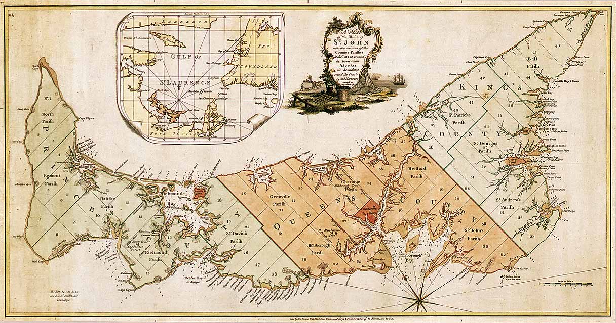
English: Map of Prince Edward Island in 1775. Titled: "A plan of the island of St. John with the divisions of the counties parishes & the lots as granted by government likewise the soundings round the coast and harbours. Surveyed by Capt. Holland. 1775." The island was the first of the new English colonies for which a general survey was conducted. Samuel Holland was in charge of the survey. Known as Île Saint-Jean at the time of the French, and later Saint John Island, it did not take its present name until 1799. This very detailed plan shows the projected counties, parishes, townships and lots on the island following the expulsion of the Acadians in 1758. Samuel Holland, surveyor general of the province of Quebec, surveyed the island in the fall of 1764. He identified the location of the capital and named it Charlottetown. The counties and townships are listed with their sizes in acres. Inset map of the Gulf of St. Lawrence. Decorative cartouche showing farming and fishing sceneries. |
||||||||||||||||||||
| Dată | |||||||||||||||||||||
| Sursă |
|
||||||||||||||||||||
| Autor |
|
||||||||||||||||||||


Licențiere
|
Această lucrare este, de asemenea, în domeniul public în ţările şi zonele în care durata drepturilor de autor este viaţa autorului plus 100 de ani sau mai puţin. | |
| Acest fișier a fost identificat ca fiind liber de orice restricții cunoscute privind legea drepturilor de autor, inclusiv toate drepturile conexe sau înrudite. | |
Istoricul fișierului
Apăsați pe Data și ora pentru a vedea versiunea trimisă atunci.
| Data și ora | Miniatură | Dimensiuni | Utilizator | Comentariu | |
|---|---|---|---|---|---|
| actuală | 6 decembrie 2007 04:52 | | 1.216x639 (167 KB) | SriMesh | |
| 6 decembrie 2007 04:51 |  | 1.216x639 (167 KB) | SriMesh | ||
| 6 decembrie 2007 04:45 |  | 1.500x791 (1,02 MB) | SriMesh | {{Information |Description=Prince Edward Island map 1765 |Source=Library and Archives Canada |Date=2007-12-05 |Author=Holland, Samuel |Permission=unrestricted public domain material, which can be reproduced without permission. |
Utilizarea fișierului
Următoarele pagini conțin această imagine:
Utilizarea globală a fișierului
Următoarele alte proiecte wiki folosesc acest fișier:
- Utilizare la bg.wikipedia.org
- Utilizare la de.wikipedia.org
- Utilizare la en.wikipedia.org
- Utilizare la ka.wikipedia.org
- Utilizare la mk.wikipedia.org
- Utilizare la mn.wikipedia.org
- Utilizare la pt.wikipedia.org