
Fișier:Lexington Concord Siege of Boston.jpg
Mărește rezoluția imaginii (3.211 × 2.476 pixeli, mărime fișier: 1,55 MB, tip MIME: image/jpeg)
| Acest fișier se află la Wikimedia Commons. Consultați pagina sa descriptivă acolo. |
Descriere fișier
| Descriere |
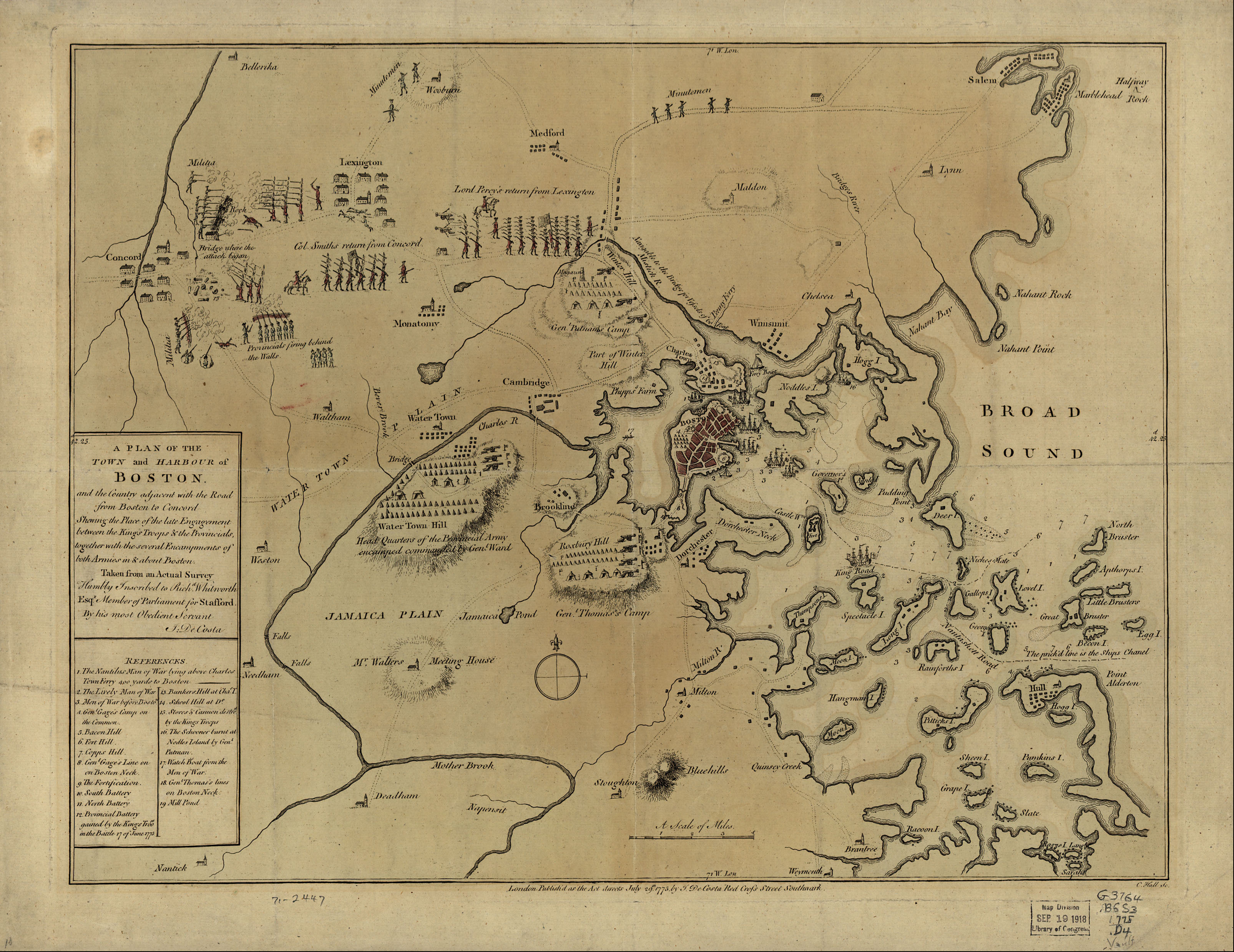
English: A mostly accurate hand-colored map depicting the 1775 Battles of Lexington and Concord and the Siege of Boston |
| Dată | |
| Sursă |
From the Library of Congress American Memory. |
| Autor | J. DeCosta |
| Alte versiuni |
 |
Large text box
TOWN and HARBOUR of
Boston.
and the Country adjacent with the Road
from Boston to Concord
Shewing the Place of the late Engagement
between the King's Troops & the Provincials,
together with the several Encampments of
both Armies in & about Boston.
Taken from an Actual Survey
Humbly Inscribed to Rich d. Whitworth
Esqr. Member of Parliament for Stafford
Legend
References.
- The Nautilus Man of War lying above Charles
- Town Ferry 400 yards to Boston
- The Lively Man of War
- Men of War before Boston.
- Gen l. Gage's Camp on
- the Common.
- Bacon Hill [i.e. Beacon Hill]
- Fort Hill.
- Copps Hill.
- Gen l. Gage's Line on
- on Boston Neck.
- The Fortification.
- South Battery
- North Battery
- Provincial Battery
- gained by the King's Troo ps
- in the Battle 17 of June 1775
- Bunkers Hill at Cha s. T.
- School Hill at D o.
- Stores & Cannon destro d
- by the King's Troops
- The Schooner burnt at
- Nodles Island by Gen l.
- Putman
- Watch Boat from the Men of War.
- Gen l. Thomas's lines
- on Boston Neck
- Mill Pond
Text along the bottom
- London Publish'd as the Act directs July 29th. 1775 by J. De Costa Red Croſs Street Southwark.

|
Această map este disponibilă pe pagina Geography & Map Division a Bibliotecii Congresului Statelor Unite ale Americii, sub numărul de identificare g3764b.ar090000.
Acest format nu indică statutul de drept de autor sau sursa lucrării atașate. Un format normal și o sursă sunt de asemenea necesare. Vezi Commons:Licenţiere pentru mai multe informații.
|
|
Această lucrare este, de asemenea, în domeniul public în ţările şi zonele în care durata drepturilor de autor este viaţa autorului plus 100 de ani sau mai puţin. | |
| Acest fișier a fost identificat ca fiind liber de orice restricții cunoscute privind legea drepturilor de autor, inclusiv toate drepturile conexe sau înrudite. | |
Istoricul fișierului
Apăsați pe Data și ora pentru a vedea versiunea trimisă atunci.
| Data și ora | Miniatură | Dimensiuni | Utilizator | Comentariu | |
|---|---|---|---|---|---|
| actuală | 10 mai 2005 10:30 | | 3.211x2.476 (1,55 MB) | Flying Jazz | "A plan of the town and harbour of Boston and the country adjacent with the road from Boston to Concord, shewing the place of the late engagement between the King's troops & the provincials, together with the several encampments of both armies in & about |
Utilizarea fișierului
Următoarele pagini conțin această imagine:
Utilizarea globală a fișierului
Următoarele alte proiecte wiki folosesc acest fișier:
- Utilizare la azb.wikipedia.org
- Utilizare la az.wikipedia.org
- Utilizare la ca.wikipedia.org
- Utilizare la cs.wikipedia.org
- Utilizare la da.wikipedia.org
- Utilizare la de.wikipedia.org
- Utilizare la en.wikipedia.org
- Utilizare la en.wikivoyage.org
- Utilizare la es.wikipedia.org
- Utilizare la fi.wikipedia.org
- Utilizare la fo.wikipedia.org
- Utilizare la fr.wikipedia.org
- Utilizare la fr.wikiversity.org
- Utilizare la it.wikipedia.org
- Utilizare la it.wikivoyage.org
- Utilizare la ja.wikipedia.org
- Utilizare la no.wikipedia.org
- Utilizare la pl.wikipedia.org
- Utilizare la sr.wikipedia.org
- Utilizare la th.wikipedia.org
- Utilizare la www.wikidata.org
- Utilizare la zh.wikipedia.org