
Fișier:Cuban crisis map missile range.jpg
Mărimea acestei previzualizări: 603 × 599 pixeli. Alte rezoluții: 241 × 240 pixeli | 483 × 480 pixeli | 666 × 662 pixeli.
Mărește rezoluția imaginii (666 × 662 pixeli, mărime fișier: 198 KB, tip MIME: image/jpeg)
| Acest fișier se află la Wikimedia Commons. Consultați pagina sa descriptivă acolo. |

|
Acest fișier a fost înlocuit cu File:The relative ranges of the IL-28, SS-4, and SS-5, stationed on Cuba.png. Se recomandă folosirea celuilalt fișier. Notă: Acest fișier nu va fi șters decât prin cererea explicită în cadrul nominalizărilor pentru ștergere. Motiv: A PNG version of this file is now available.
|

|
| Descriere |
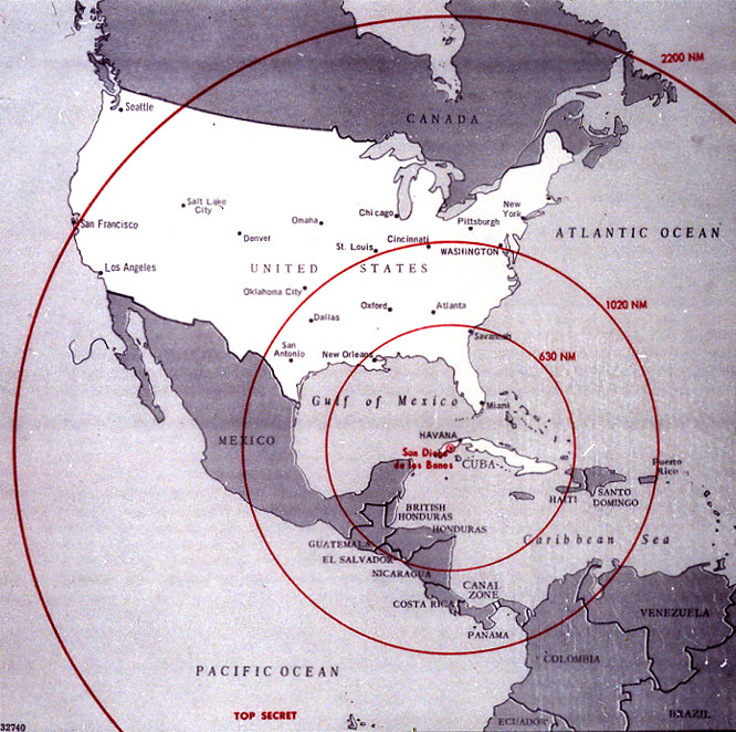
English: Map of Northern America showing the full range of the nuclear missiles under construction in Cuba, used during the secret meetings on the Cuban crisis. Deutsch: Diese Karte der westlichen Hemisphäre zeigt die volle Reichweite der Atomraketen, die auf Kuba im Rahmen der Kubakrise stationiert werden sollten bzw. worden sind. Diese Karte wurde bei den geheimen Treffen während der Kubakrise verwendet. Die Karte war ehemals Top Secret. Die eingezeichneten Radien sind in Nautischen Meilen (1 NM ~ 1,852 km) bemaßt; die 1020 NM (~ 1900 km) entsprechen ungefähr der taktischen Reichweite der SS-4, die 2200 NM (~ 4000 km) jener der SS-5. |
|||
| Dată | ||||
| Sursă | The John F. Kennedy Presidential Library and Museum, Boston. [1] | |||
| Autor | CIA | |||
| Permisiune (Reutilizarea acestui fișier) |
|

![[1]](http://www.jfklibrary.org/jfkl/cmc/cmc_map_missile_range.jpg)
Istoricul fișierului
Apăsați pe Data și ora pentru a vedea versiunea trimisă atunci.
| Data și ora | Miniatură | Dimensiuni | Utilizator | Comentariu | |
|---|---|---|---|---|---|
| actuală | 9 ianuarie 2009 00:18 | | 666x662 (198 KB) | PaulBommel | {{Information |Description= |Source= |Date= |Author= |Permission= |other_versions= }} |
| 9 iunie 2007 19:31 |  | 700x920 (249 KB) | Nickel Chromo~commonswiki | {{Information| |Description= '''English''': Map of the western hemisphere showing the full range of the nuclear missiles under construction in Cuba, used during the secret meetings on the Cuban crisis. |Source= The John F. Kennedy Presidential Library and |
Utilizarea fișierului
Următoarele pagini conțin această imagine:
Utilizarea globală a fișierului
Următoarele alte proiecte wiki folosesc acest fișier:
- Utilizare la ar.wikipedia.org
- Utilizare la ba.wikipedia.org
- Utilizare la bg.wikipedia.org
- Utilizare la da.wikipedia.org
- Utilizare la en.wikipedia.org
- Utilizare la en.wikiquote.org
- Utilizare la eo.wikipedia.org
- Utilizare la es.wikipedia.org
- Utilizare la fi.wikipedia.org
- Utilizare la fi.wikibooks.org
- Utilizare la ga.wikipedia.org
- Utilizare la hr.wikipedia.org
- Utilizare la it.wikipedia.org
- Utilizare la lv.wikipedia.org
- Utilizare la no.wikibooks.org
- Utilizare la rm.wikipedia.org
- Utilizare la ru.wikipedia.org
- Utilizare la sr.wikipedia.org
- Utilizare la sv.wikipedia.org
- Utilizare la th.wikipedia.org
- Utilizare la uk.wikipedia.org