
Fișier:Civitas Londinium or The Agas Map of London.jpg

Mărimea acestei previzualizări: 800 × 338 pixeli. Alte rezoluții: 320 × 135 pixeli | 640 × 271 pixeli | 1.024 × 433 pixeli | 1.280 × 541 pixeli | 4.730 × 2.000 pixeli.
Mărește rezoluția imaginii (4.730 × 2.000 pixeli, mărime fișier: 4,08 MB, tip MIME: image/jpeg)
| Acest fișier se află la Wikimedia Commons. Consultați pagina sa descriptivă acolo. |
Descriere fișier
| Descriere |
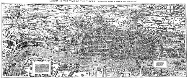
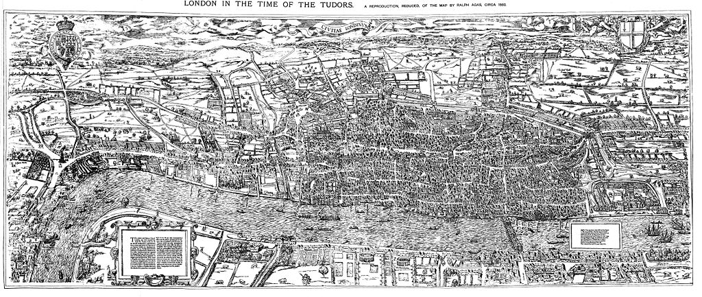
English: The earliest proper map (as opposed to panorama) of London known. Attributed to Ralph Agas, and probably surveyed between 1570 and 1605. The original was 6 foot 0.5 inches long by 2 feet 4.5 inches wide. This much reduced image is a scan of a copy of a lithograph of a copy, was itself badly repaired with sellotape and has had to be "restored"; so is hardly a truly faithful representation of the original, but few good copies exist and no other detailed public domain images are known. |
| Dată | |
| Sursă | Maps of Old London, London, Adam and Charles Black, 1908. Scanned & corrected Mike Calder. |
| Autor | Mike Calder, image of Civitas Londinium, Agas' Map of London, c. 1570-1605 |
| Alte versiuni | Creații derivate din acest fișier: Covent Garden from the Ralph Agas 1572 map of London.jpg |
Licențiere
|
Această lucrare este, de asemenea, în domeniul public în ţările şi zonele în care durata drepturilor de autor este viaţa autorului plus 100 de ani sau mai puţin. | |
| Acest fișier a fost identificat ca fiind liber de orice restricții cunoscute privind legea drepturilor de autor, inclusiv toate drepturile conexe sau înrudite. | |
Istoricul fișierului
Apăsați pe Data și ora pentru a vedea versiunea trimisă atunci.
| Data și ora | Miniatură | Dimensiuni | Utilizator | Comentariu | |
|---|---|---|---|---|---|
| actuală | 14 august 2009 21:59 | | 4.730x2.000 (4,08 MB) | MikeCalder | {{Information |Description={{en|1=The earliest proper map (as opposed to panorama) of London known. Attributed to Ralph Agas, and probably surveyed between 1570 and 1605. The original was 6 foot 0.5 inches long by 2 feet 4.5 inches wide. This much reduc |
Utilizarea fișierului
Următoarele pagini conțin această imagine:
Utilizarea globală a fișierului
Următoarele alte proiecte wiki folosesc acest fișier:
- Utilizare la af.wikipedia.org
- Utilizare la ar.wikipedia.org
- Utilizare la avk.wikipedia.org
- Utilizare la azb.wikipedia.org
- Utilizare la de.wikipedia.org
- Utilizare la el.wikipedia.org
- Utilizare la en.wikipedia.org
- Utilizare la es.wikipedia.org
- Utilizare la fa.wikipedia.org
- Utilizare la hy.wikipedia.org
- Utilizare la it.wikipedia.org
- Utilizare la ja.wikipedia.org
- Utilizare la ko.wikipedia.org
- Utilizare la la.wikipedia.org
- Utilizare la pt.wikipedia.org
- Utilizare la ru.wikipedia.org
- Utilizare la simple.wikipedia.org
- Utilizare la sl.wikipedia.org
- Utilizare la tr.wikipedia.org
- Utilizare la uk.wikipedia.org
- Utilizare la zh.wikipedia.org