
Fișier:150132main image feature 589 alaska.jpg

Mărește rezoluția imaginii (5.600 × 4.400 pixeli, mărime fișier: 6,63 MB, tip MIME: image/jpeg)
| Acest fișier se află la Wikimedia Commons. Consultați pagina sa descriptivă acolo. |
Descriere fișier
| Descriere |
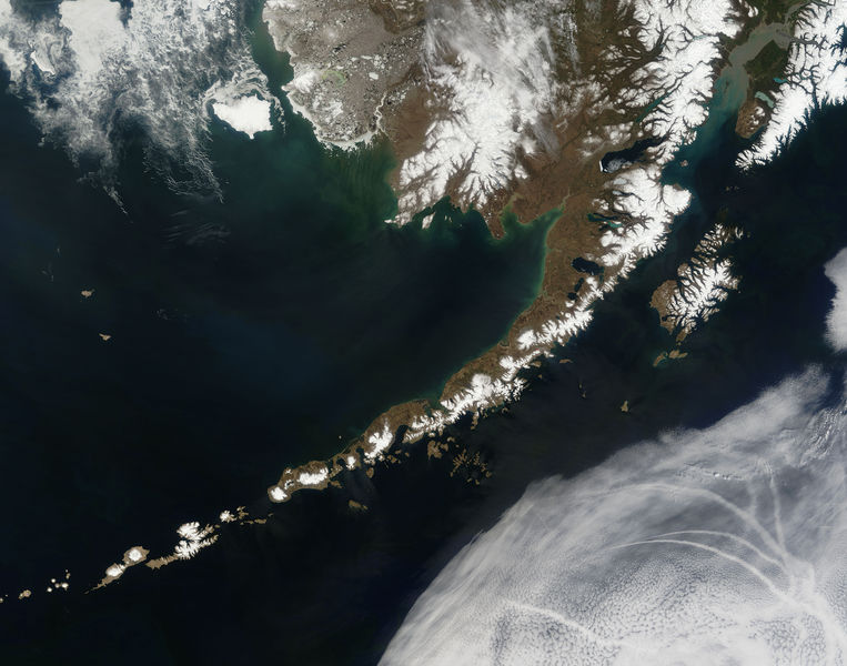
English: Satellite picture of the Aleutian Islands and the Alaska Peninsula, located in the south of the state of Alaska, United States.
Português: Imagem de satélite das Ilhas Aleutas e da Península do Alasca, localizadas no sul do estado do Alasca, Estados Unidos.
Original caption — The Aleutian Islands and the Alaskan peninsula are shown in this image acquired by the MODIS on the Terra satellite, on May 25th, 2006. The Aleutians are a chain of more than 300 small volcanic islands forming an island arc in the Northern Pacific Ocean. They extend about 1,200 miles westward from the Alaskan Peninsula. Nearly all of the islands are part of Alaska, but at the extreme western end of the archipelago are the small, geologically-related, but remote Komandorski Islands, which are considered part of Russia. The Aleutian Islands, with 57 volcanoes among them, are in the northern part of the Pacific Ring of Fire.
|
| Dată | 25 mai 2006 |
| Sursă | NASA (Image galleries) |
| Autor | National Aeronautics and Space Administration (NASA) |
| Alte versiuni |
.jpg)
Assessment
Această fotografie a fost aleasă ca imagine a zilei în data de 2 septembrie 2006. Descrierea originală era: Alte limbi:
Bân-lâm-gú: Ùi thài-khong koàⁿ Aleutian Kûn-tó kap Alaska Poàⁿ-tó Čeština: Aleutské ostrovy z oběžné dráhy. Cymraeg: Delwedd o'r gofod o'r Ynysoedd Aleutia a'r Gorynys Alaska. Magyar: Az Aleut-szigetek és az Alaszkai-félsziget az űrből nézve Polski: Aleuty i półwysep Alaska widziane z orbity ziemskiej Slovenščina: Aleutski otoki iz vesolja. |
Licențiere
| Acest fişier este în domeniul public fiindcă a fost creat de NASA. Politica drepturilor de autor a NASA spune că „Materialul NASA nu este protejat de dreptul de autor atâta timp cât nu se precizează altfel”. (NASA copyright policy page sau JPL Image Use Policy). | ||
 |
Atenţie:
|
Istoricul fișierului
Apăsați pe Data și ora pentru a vedea versiunea trimisă atunci.
| Data și ora | Miniatură | Dimensiuni | Utilizator | Comentariu | |
|---|---|---|---|---|---|
| actuală | 14 iulie 2006 22:55 | | 5.600x4.400 (6,63 MB) | Felipe Menegaz | {{Information| |Description= The Aleutian Islands and the Alaskan peninsula are shown in this image acquired by the MODIS on the Terra satellite, on May 25th, 2006. The Aleutians are a chain of more than 300 small volcanic islands forming an island arc in |
Utilizarea fișierului
Următoarele pagini conțin această imagine:
Utilizarea globală a fișierului
Următoarele alte proiecte wiki folosesc acest fișier:
- Utilizare la af.wikipedia.org
- Utilizare la als.wikipedia.org
- Utilizare la bn.wikipedia.org
- Utilizare la ca.wikipedia.org
- Utilizare la cs.wikipedia.org
- Utilizare la de.wikipedia.org
- Utilizare la eo.wikipedia.org
- Utilizare la es.wikipedia.org
- Utilizare la fr.wikipedia.org
- Utilizare la gl.wikipedia.org
- Utilizare la hu.wikipedia.org
- Utilizare la ia.wikipedia.org
- Utilizare la it.wikipedia.org
- Utilizare la ja.wikipedia.org
- Utilizare la ko.wikipedia.org
- Utilizare la oc.wikipedia.org
- Utilizare la os.wikipedia.org
- Utilizare la pl.wikipedia.org
- Utilizare la pl.wiktionary.org
- Utilizare la pt.wikipedia.org
- Utilizare la ru.wikipedia.org
- Utilizare la ru.wikinews.org
- Utilizare la sah.wikipedia.org
- Utilizare la sk.wikipedia.org
- Utilizare la sr.wikipedia.org
- Utilizare la sv.wikipedia.org
- Utilizare la tr.wikipedia.org