
Fișier:Syria 2004 CIA map-2010-07-09.JPG
Mărimea acestei previzualizări: 800 × 574 pixeli. Alte rezoluții: 320 × 229 pixeli | 640 × 459 pixeli | 1.004 × 720 pixeli.
Mărește rezoluția imaginii (1.004 × 720 pixeli, mărime fișier: 127 KB, tip MIME: image/jpeg)
| Acest fișier se află la Wikimedia Commons. Consultați pagina sa descriptivă acolo. |
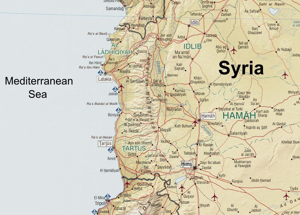
| Descriere | Syria. United States. Central Intelligence Agency. CREATED/PUBLISHED [Washington, D.C. : Central Intelligence Agency, 2004] NOTES "803011 (C00612) 1-04." Scale 1:1,300,000 ; Lambert conformal conic proj., standard parallels 32010'N and 38020'N (E 350--E 420/N 370--N 320). SUBJECTS Syria--Maps. Syria. MEDIUM 1 map : col. ; 66 x 66 cm. CALL NUMBER G7460 2004 .U5 REPOSITORY Library of Congress Geography and Map Division Washington, D.C. 20540-4650 USA DIGITAL ID g7460 ct001190 http://hdl.loc.gov/loc.gmd/g7460.ct001190 |
| Dată | (UTC) |
| Sursă | |
| Autor |
|
| Această imagine a fost retușată, ceea ce înseamnă că a fost modificată pe cale digitală și este diferită de cea inițială. Modificări: Zoomed in at the An-Nusayriyah Mountains, removed the typing "Cape Apostolos Andreas" at eastern Cyprus, removed the Golan Heights zoomed map, replaced the name "Mediterranean Sea", added the name "Syria". Imaginea inițială poate fi consultată aici: Syria 2004 CIA map.jpg. Modificările au fost efectuate de către Supreme Deliciousness.
|
| This image is a work of a Central Intelligence Agency employee, taken or made as part of that person's official duties. As a Work of the United States Government, this image or media is in the public domain in the United States.
|

|
Jurnalul original al încărcărilor
This image is a derivative work of the following images:
- File:Syria_2004_CIA_map.jpg licensed with PD-USGov-CIA
- 2005-10-26T04:43:40Z Brian0918 3200x3178 (3495939 Bytes) Syria. United States. Central Intelligence Agency. CREATED/PUBLISHED [Washington, D.C. : Central Intelligence Agency, 2004] NOTES "803011 (C00612) 1-04." Scale 1:1,300,000 ; Lambert conformal conic proj., standard paralle
Uploaded with derivativeFX
Istoricul fișierului
Apăsați pe Data și ora pentru a vedea versiunea trimisă atunci.
| Data și ora | Miniatură | Dimensiuni | Utilizator | Comentariu | |
|---|---|---|---|---|---|
| actuală | 7 septembrie 2010 15:08 | | 1.004x720 (127 KB) | Supreme Deliciousness | {{Information |Description=Syria. United States. Central Intelligence Agency. CREATED/PUBLISHED [Washington, D.C. : Central Intelligence Agency, 2004] NOTES "803011 (C00612) 1-04." Scale 1:1,300,000 ; Lambert conformal conic proj., standard parallels |
Utilizarea fișierului
Următoarele pagini conțin această imagine:
Utilizarea globală a fișierului
Următoarele alte proiecte wiki folosesc acest fișier:
- Utilizare la ar.wikipedia.org
- Utilizare la azb.wikipedia.org
- Utilizare la az.wikipedia.org
- Utilizare la bg.wikipedia.org
- Utilizare la ca.wikipedia.org
- Utilizare la en.wikipedia.org
- Utilizare la es.wikipedia.org
- Utilizare la fr.wikipedia.org
- Utilizare la it.wikipedia.org
- Utilizare la lld.wikipedia.org
- Utilizare la nn.wikipedia.org
- Utilizare la pt.wikipedia.org
- Utilizare la ru.wikipedia.org
- Utilizare la tr.wikipedia.org
- Utilizare la uk.wikipedia.org
- Utilizare la ur.wikipedia.org
- Utilizare la vi.wikipedia.org
- Utilizare la www.wikidata.org
- Utilizare la zh.wikipedia.org